IMAGES TAKEN NEAR TO
Rosetta Road, NOTTINGHAM, NG7 7GG
Introduction
This page details the photographs taken nearby to Rosetta Road, NG7 7GG by members of the Geograph project.
The Geograph project started in 2005 with the aim of publishing, organising and preserving representative images for every square kilometre of Great Britain, Ireland and the Isle of Man.

There are currently over 7.5m images from over14,400 individuals and you can help contribute to the project by visiting https://www.geograph.org.uk
Image Map (Loading...)


Getting Data...Please wait
Leaflet Map data © OpenStreetMap
Images are licensed for reuse under creativecommons.org/licenses/by-sa/2.0
Notes
- Clicking on the map will re-center to the selected point.
- The higher the marker number, the further away the image location is from the centre of the postcode.
Image Listing (79 Images Found)
Images are licensed for reuse under creativecommons.org/licenses/by-sa/2.0
Image
Details
Distance
1
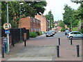
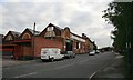
Zulu Road
The streets between Radford Road and Nottingham Road have been adapted to prevent their use as rat runs. The area in the foreground allows for the passage of the emergency services.
Image: © Alan Murray-Rust
Taken: 24 Jun 2008
0.08 miles
2
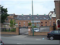
Former maltings, Radford Road
Converted to offices, these old malting appear to be untenanted.
Image: © Alan Murray-Rust
Taken: 24 Jun 2008
0.08 miles
3
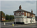
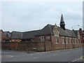
Clinton Arms
An attractive late Victorian corner pub, now closed.
Image: © Alan Murray-Rust
Taken: 24 Jun 2008
0.09 miles
4

Bench mark, former Clinton Arms
See http://www.geograph.org.uk/photo/5053890 for location.
Image: © Alan Murray-Rust
Taken: 27 Jul 2016
0.09 miles
5

Former Clinton Arms, Radford
Little changed from this 2008 view http://www.geograph.org.uk/photo/860261 although it is no longer boarded up and is not let as apartments. There is a bench mark http://www.geograph.org.uk/photo/5053886 on the near end of the main road facade.
Image: © Alan Murray-Rust
Taken: 27 Jul 2016
0.10 miles
6

The Gates of Nottingham (11)
"Northgate - the only one of Nottingham's gates outside the old medieval city area.
Nottingham has some 15 streets incorporating the Norse-derived 'Gate', meaning a thoroughfare, not a barrier."
Next in series Image
Image: © Alan Murray-Rust
Taken: 11 Feb 2007
0.10 miles
7
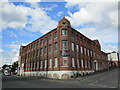
Former Peter Mathieson and Sons Ltd. Perambulator Works, Radford Road
The company operated from here from 1921 until 1965.
My thanks to Keith Hart for providing me with information about this building.
Image: © Jonathan Thacker
Taken: 3 Jul 2022
0.12 miles
8
Bottom of Northgate
I seem to remember that the building now used by a storage company is a former bus depot. But I need to confirm this.
Image: © Mick Garratt
Taken: 29 Aug 2007
0.12 miles
9
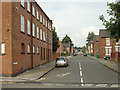
Chelmsford Road
Part of the network of streets of terraced housing between Radford Road and Nottingham Road. To the left a textile factory converted to flats.
Image: © Alan Murray-Rust
Taken: 24 Jun 2008
0.12 miles
10
Former school, Radford Road
Now converted to industrial use. All the old pupil entrances have been walled up.
Image: © Alan Murray-Rust
Taken: 24 Jun 2008
0.13 miles