IMAGES TAKEN NEAR TO
Radford Road, NOTTINGHAM, NG7 7EX
Introduction
This page details the photographs taken nearby to Radford Road, NG7 7EX by members of the Geograph project.
The Geograph project started in 2005 with the aim of publishing, organising and preserving representative images for every square kilometre of Great Britain, Ireland and the Isle of Man.

There are currently over 7.5m images from over14,400 individuals and you can help contribute to the project by visiting https://www.geograph.org.uk
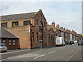
Image Map
Images are licensed for reuse under creativecommons.org/licenses/by-sa/2.0
Notes
- Clicking on the map will re-center to the selected point.
- The higher the marker number, the further away the image location is from the centre of the postcode.
Image Listing (172 Images Found)
Images are licensed for reuse under creativecommons.org/licenses/by-sa/2.0
Image
Details
Distance
1
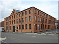
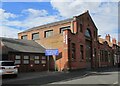
Former textile factory, Radford Road
Now converted into apartments
Image: © Alan Murray-Rust
Taken: 24 Jun 2008
0.00 miles
2
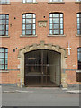
Entrance to former textile factory
The entrance to Image Datestone over the gateway; the corbels carry the firm's initials, MW (or maybe WM)
Image: © Alan Murray-Rust
Taken: 24 Jun 2008
0.00 miles
3

Bench mark, Radford Road
See http://www.geograph.org.uk/photo/5053905 for location.
Image: © Alan Murray-Rust
Taken: 27 Jul 2016
0.03 miles
4
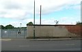
Former gasworks site, Radford
A very nondescript picture, taken purely to locate a bench mark http://www.geograph.org.uk/photo/5053903 , at the base of the wall roughly in line with the shrub growing out of the top of the wall.
Image: © Alan Murray-Rust
Taken: 27 Jul 2016
0.03 miles
5
St. Leodegarius Church Hall
Viewed across Nottingham Road.
Image: © Mick Garratt
Taken: 6 Jan 2007
0.04 miles
6
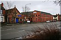
Isandula Road
The large building is a factory.
Image: © Alan Murray-Rust
Taken: 24 Jun 2008
0.07 miles
7
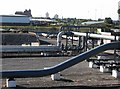
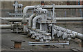
Basford: gas depot
This space was once occupied by the huge Nottingham Corporation Gas Works, of which only the two large gas holders remain - one is in the middle distance, left of centre. To the right is the NET tram depot at Wilkinson Street. On the skyline are the former Shipstone's Brewery (left) and - much further away - the tower blocks on Hartley Road in Radford.
Image: © John Sutton
Taken: 13 Sep 2011
0.07 miles
8
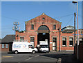
Isandula Road: former sub-station
This building, now occupied by a glazing company, was originally an electricity sub-station, and not, as I had originally thought, the horse tram depot which old OS maps show was on the other side of Isandula Road and was demolished in the 1980s. I am grateful to J D Oaks for correcting me.
Image: © John Sutton
Taken: 28 Apr 2011
0.07 miles
10
Glass works, Isandula Road
Appears to be a former chapel.
Image: © Jonathan Thacker
Taken: 3 Jul 2022
0.08 miles