IMAGES TAKEN NEAR TO
Zulu Road, NOTTINGHAM, NG7 7DS
Introduction
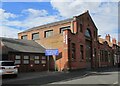
This page details the photographs taken nearby to Zulu Road, NG7 7DS by members of the Geograph project.
The Geograph project started in 2005 with the aim of publishing, organising and preserving representative images for every square kilometre of Great Britain, Ireland and the Isle of Man.

There are currently over 7.5m images from over14,400 individuals and you can help contribute to the project by visiting https://www.geograph.org.uk
Image Map
Images are licensed for reuse under creativecommons.org/licenses/by-sa/2.0
Notes
- Clicking on the map will re-center to the selected point.
- The higher the marker number, the further away the image location is from the centre of the postcode.
Image Listing (121 Images Found)
Images are licensed for reuse under creativecommons.org/licenses/by-sa/2.0
Image
Details
Distance
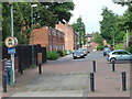
1
Chelmsford Road
Part of the network of streets of terraced housing between Radford Road and Nottingham Road. To the left a textile factory converted to flats.
Image: © Alan Murray-Rust
Taken: 24 Jun 2008
0.01 miles
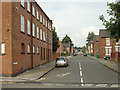
2
Zulu Road
The streets between Radford Road and Nottingham Road have been adapted to prevent their use as rat runs. The area in the foreground allows for the passage of the emergency services.
Image: © Alan Murray-Rust
Taken: 24 Jun 2008
0.04 miles
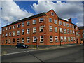
3
Former textile factory
These premises on Radford Road have now been converted to residential accommodation.
Image: © Alan Murray-Rust
Taken: 6 May 2008
0.05 miles
4

The Rafters, Radford Road
Possibly originally a textile factory, later certainly a cane furniture factory, now converted to apartments.
There is a bench mark http://www.geograph.org.uk/photo/5053896 on the corner, facing Radford Road.
Image: © Alan Murray-Rust
Taken: 27 Jul 2016
0.06 miles
5
Former factory, Radford Road
Now apartments.
Image: © Jonathan Thacker
Taken: 3 Jul 2022
0.06 miles
6
Glass works, Isandula Road
Appears to be a former chapel.
Image: © Jonathan Thacker
Taken: 3 Jul 2022
0.07 miles
7

Bench mark, 576 Radford Road
See http://www.geograph.org.uk/photo/5053892 for location.
Image: © Alan Murray-Rust
Taken: 27 Jul 2016
0.07 miles
8
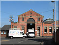
Isandula Road: former sub-station
This building, now occupied by a glazing company, was originally an electricity sub-station, and not, as I had originally thought, the horse tram depot which old OS maps show was on the other side of Isandula Road and was demolished in the 1980s. I am grateful to J D Oaks for correcting me.
Image: © John Sutton
Taken: 28 Apr 2011
0.07 miles
9
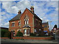
The Sanctuary, Mary Magdalene Foundation
Provides counselling services.
Image: © Jonathan Thacker
Taken: 3 Jul 2022
0.07 miles
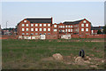
10
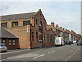
Isandula Road
The large building is a factory.
Image: © Alan Murray-Rust
Taken: 24 Jun 2008
0.07 miles