IMAGES TAKEN NEAR TO
Laurie Avenue, NOTTINGHAM, NG7 6PP
Introduction
This page details the photographs taken nearby to Laurie Avenue, NG7 6PP by members of the Geograph project.
The Geograph project started in 2005 with the aim of publishing, organising and preserving representative images for every square kilometre of Great Britain, Ireland and the Isle of Man.

There are currently over 7.5m images from over14,400 individuals and you can help contribute to the project by visiting https://www.geograph.org.uk
Image Map
Images are licensed for reuse under creativecommons.org/licenses/by-sa/2.0
Notes
- Clicking on the map will re-center to the selected point.
- The higher the marker number, the further away the image location is from the centre of the postcode.
Image Listing (209 Images Found)
Images are licensed for reuse under creativecommons.org/licenses/by-sa/2.0
Image
Details
Distance
1
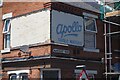
Apollo Table Waters
Ghost sign on a former corner shop Hardcourt Road and Laurie Avenue.
Image: © David Lally
Taken: 17 Jul 2021
0.01 miles

3
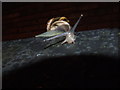
Snail
Snail on a garden wall, Harcourt Road ~ a wet July 2007 evening
Image: © Richard Dawson
Taken: 15 Jul 2007
0.05 miles
4
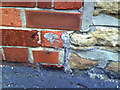
Remains of benchmark on side of #44 Leslie Road
Remaining parts of damaged Ordnance Survey cut mark benchmark which is described on the Bench Mark Database at http://www.bench-marks.org.uk/bm35198.
Image: © Roger Templeman
Taken: 10 Aug 2010
0.06 miles
5
Junction of Leslie Road and Wiverton Road
There is a damaged OS benchmark Image on the corner of the near house at its junction with the stone wall
Image: © Roger Templeman
Taken: 31 Mar 2013
0.06 miles
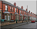
6
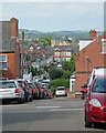
Up Stanley Road
Looking up the hill towards Berridge Road from the corner of Laurie Avenue on a showery May morning.
Image: © John Sutton
Taken: 12 May 2014
0.08 miles
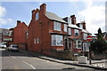
7
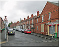
Forest Fields: Exeter Road
The Forest Fields district was built as Nottingham expanded hugely in the last decades of the nineteenth century. Terraces in these styles can be found all over the city.
Image: © John Sutton
Taken: 12 Sep 2018
0.09 miles
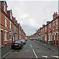
8
Stanley Road: bays and Bulwell stone walls
These houses have ground-floor bays, tiny front gardens and that most characteristic Nottingham feature, Bulwell stone garden walls. The houses on the other side of the road open on to the street (see Image]).
Image: © John Sutton
Taken: 12 May 2014
0.09 miles
9
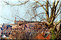
Forest Fields skyline, 1993
A long telephoto view from near the corner of Bentinck Road. Mount Street Mill is on the skyline, behind the gables, tall chimney stacks and spirelet of my old school, now refurbished as Forest Fields Primary School.
Image: © John Sutton
Taken: 13 Mar 1993
0.09 miles
10
Forest Fields: west from Wiverton Road
A foreshortened zoom shot along Wiverton Road and Austen Avenue, with the former St Paul's Church tower at Hyson Green in the centre. Wollaton Church spire is much further away and beyond the western suburbs are the hills around Trowell and the Erewash Valley.
Image: © John Sutton
Taken: 6 Jul 2015
0.09 miles