IMAGES TAKEN NEAR TO
Laurie Avenue, NOTTINGHAM, NG7 6PH
Introduction
This page details the photographs taken nearby to Laurie Avenue, NG7 6PH by members of the Geograph project.
The Geograph project started in 2005 with the aim of publishing, organising and preserving representative images for every square kilometre of Great Britain, Ireland and the Isle of Man.

There are currently over 7.5m images from over14,400 individuals and you can help contribute to the project by visiting https://www.geograph.org.uk
Image Map
Images are licensed for reuse under creativecommons.org/licenses/by-sa/2.0
Notes
- Clicking on the map will re-center to the selected point.
- The higher the marker number, the further away the image location is from the centre of the postcode.
Image Listing (213 Images Found)
Images are licensed for reuse under creativecommons.org/licenses/by-sa/2.0
Image
Details
Distance
1
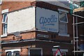
Apollo Table Waters
Ghost sign on a former corner shop Hardcourt Road and Laurie Avenue.
Image: © David Lally
Taken: 17 Jul 2021
0.01 miles

3
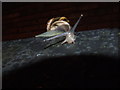
Snail
Snail on a garden wall, Harcourt Road ~ a wet July 2007 evening
Image: © Richard Dawson
Taken: 15 Jul 2007
0.03 miles
4
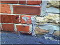
Remains of benchmark on side of #44 Leslie Road
Remaining parts of damaged Ordnance Survey cut mark benchmark which is described on the Bench Mark Database at http://www.bench-marks.org.uk/bm35198.
Image: © Roger Templeman
Taken: 10 Aug 2010
0.06 miles
5
Junction of Leslie Road and Wiverton Road
There is a damaged OS benchmark Image on the corner of the near house at its junction with the stone wall
Image: © Roger Templeman
Taken: 31 Mar 2013
0.06 miles
6
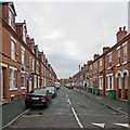
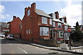
Forest Fields: Exeter Road
The Forest Fields district was built as Nottingham expanded hugely in the last decades of the nineteenth century. Terraces in these styles can be found all over the city.
Image: © John Sutton
Taken: 12 Sep 2018
0.06 miles
7
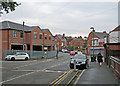
Forest Fields: building on Berridge Road
The new building on the left, on the corner of Leslie Road, replaces the semi-detached houses and garage shown in part in Roger Templeman's Image] (2013).
Image: © John Sutton
Taken: 12 Sep 2018
0.08 miles
8
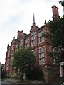
Former Grammar School, Stanley Road
When High Pavement Grammar School moved to new buildings in 1956 a new, co-educational grammar school, Forest Fields, opened in the Stanley Road building. Forest Fields moved to Carlton Hill some time in the 1970s and now is no more.
Image: © John Sutton
Taken: 11 Oct 2006
0.08 miles
9
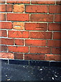
Ordnance Survey BOGOF offer?
Ordnance Survey cut mark benchmarks on RKD Service Station at junction of Leslie Road and Berridge Road. The mark is described on the Bench Mark Database at http://www.bench-marks.org.uk/bm35199.
Image: © Roger Templeman
Taken: 10 Aug 2010
0.08 miles
10

Junction of Berridge Road and Leslie Road
There are two OS benchmarks Image on the garage building wall left of the lamp post
Image: © Roger Templeman
Taken: 31 Mar 2013
0.08 miles