IMAGES TAKEN NEAR TO
Austen Avenue, NOTTINGHAM, NG7 6PF
Introduction
This page details the photographs taken nearby to Austen Avenue, NG7 6PF by members of the Geograph project.
The Geograph project started in 2005 with the aim of publishing, organising and preserving representative images for every square kilometre of Great Britain, Ireland and the Isle of Man.

There are currently over 7.5m images from over14,400 individuals and you can help contribute to the project by visiting https://www.geograph.org.uk
Image Map (Loading...)


Getting Data...Please wait
Leaflet Map data © OpenStreetMap
Images are licensed for reuse under creativecommons.org/licenses/by-sa/2.0
Notes
- Clicking on the map will re-center to the selected point.
- The higher the marker number, the further away the image location is from the centre of the postcode.
Image Listing (233 Images Found)
Images are licensed for reuse under creativecommons.org/licenses/by-sa/2.0
Image
Details
Distance
1
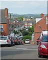
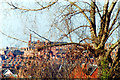
Forest Fields: west from Wiverton Road
A foreshortened zoom shot along Wiverton Road and Austen Avenue, with the former St Paul's Church tower at Hyson Green in the centre. Wollaton Church spire is much further away and beyond the western suburbs are the hills around Trowell and the Erewash Valley.
Image: © John Sutton
Taken: 6 Jul 2015
0.01 miles
2
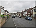
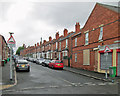
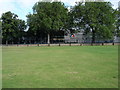
Forest Fields: Austen Avenue
Most of Forest Fields dates from the end of the 19th century and the early years of the 20th. This was one of the last parts to be developed
Image: © John Sutton
Taken: 12 May 2014
0.01 miles
3
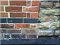
Benchmark on #48 Russell Road
Ordnance Survey cut mark benchmark described on the Bench Mark Database at http://www.bench-marks.org.uk/bm35200.
Image: © Roger Templeman
Taken: 10 Aug 2010
0.05 miles
4
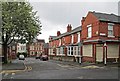
Forest Fields: the corner of Russell Road and Laurie Avenue
Looking along Laurie Avenue towards Burford Road on a drab May morning.
Image: © John Sutton
Taken: 12 May 2014
0.07 miles
5
Up Stanley Road
Looking up the hill towards Berridge Road from the corner of Laurie Avenue on a showery May morning.
Image: © John Sutton
Taken: 12 May 2014
0.09 miles
6
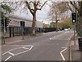
Nottingham - NG5 (Gregory Boulevard)
In this central section of Gregory Boulevard – an avenue constructed and planted out in 1881 – is “The 11-14 Centre” (component) of Djanogly City Academy specialising in information and computer technology. The building, on the former Forest Comprehensive School site, was designed by Foster & Partners and opened in 2003 to replace the Djanogly City Technology College. Both institutions were named after their sponsor, Sir Harry Djanogly, the textile millionaire. Opposite the academy is The Forest, home of the annual Goose Fair.
Image: © David Hallam-Jones
Taken: 5 May 2012
0.09 miles
7
Forest Fields skyline, 1993
A long telephoto view from near the corner of Bentinck Road. Mount Street Mill is on the skyline, behind the gables, tall chimney stacks and spirelet of my old school, now refurbished as Forest Fields Primary School.
Image: © John Sutton
Taken: 13 Mar 1993
0.10 miles
8
Djanogly City Academy
Built on the site of the former Manning Grammar School.
Image: © A J Paxton
Taken: 26 Sep 2009
0.10 miles
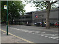
9
Djanogly City Academy - Forest Campus
This new building was built 3 or 4 years ago to replace the old Forest comprehensive school. The long (about 3 - 400 metres) and low building is faced with glass and aluminium, and it makes an interesting contrast with the many substantial brick buildings (housing, public buildings, and industrial sites) in this area of Nottingham.
Image: © Oxymoron
Taken: 17 Aug 2008
0.10 miles
10
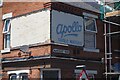
Apollo Table Waters
Ghost sign on a former corner shop Hardcourt Road and Laurie Avenue.
Image: © David Lally
Taken: 17 Jul 2021
0.10 miles