IMAGES TAKEN NEAR TO
Gregory Boulevard, NOTTINGHAM, NG7 6NX
Introduction
This page details the photographs taken nearby to Gregory Boulevard, NG7 6NX by members of the Geograph project.
The Geograph project started in 2005 with the aim of publishing, organising and preserving representative images for every square kilometre of Great Britain, Ireland and the Isle of Man.

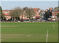
There are currently over 7.5m images from over14,400 individuals and you can help contribute to the project by visiting https://www.geograph.org.uk
Image Map
Images are licensed for reuse under creativecommons.org/licenses/by-sa/2.0
Notes
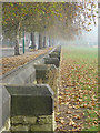
- Clicking on the map will re-center to the selected point.
- The higher the marker number, the further away the image location is from the centre of the postcode.
Image Listing (182 Images Found)
Images are licensed for reuse under creativecommons.org/licenses/by-sa/2.0
Image
Details
Distance
1
Beside The Forest fence
As can be seen, the fence itself has been long since cut away, giving the area a real feel of openness.
Image: © Alan Murray-Rust
Taken: 4 Nov 2007
0.03 miles
2
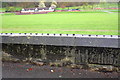
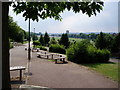
Recreation ground from Gregory Boulevard
View over wall from opposite Leslie Road of pavilion in the recreation ground. There is an Ordnance Survey cut mark benchmark described on the Bench Mark Database at http://www.bench-marks.org.uk/bm42610 on the wall at the middle of the image.
Image: © Roger Templeman
Taken: 9 Apr 2012
0.03 miles
3
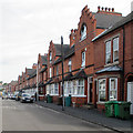
Forest Fields: a Watson Fothergill terrace
This terrace is one of the later works of Nottingham's most distinctive Victorian architect. Image] shows it from the other end.
For more about Fothergill, and photographs of most of his buildings, see http://www.geograph.org.uk/article/The-Buildings-of-Watson-Fothergill .
Image: © John Sutton
Taken: 6 Jul 2015
0.04 miles
4
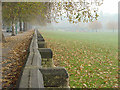
Beside The Forest fence
As can be seen, the fence itself has been long since cut away, giving the area a real feel of openness.
Image: © Alan Murray-Rust
Taken: 4 Nov 2007
0.05 miles
5
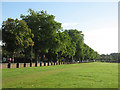
The Forest and Forest Fields
Football fields in the foreground, Forest Fields in the background, on the other side of Gregory Boulevard (marked by cars and the low Bulwell stone boundary wall). Foxhall Road climbs the hill straight ahead. The Forest came about as a result of the Enclosure Act of 1845. Forest Fields was a genteel part of the rapid expansion of the city in the last quarter of the 19th century.
Image: © John Sutton
Taken: 22 Apr 2010
0.05 miles
7
Forest Recreation Ground, Nottingham
The Forest Recreation Ground as seen from Mansfield Road. Originally used by Nottingham's racecourse, the Forest now provides the venue for the annual Goose Fair.
Image: © Steve Bradwell
Taken: 15 Jul 2005
0.07 miles
8
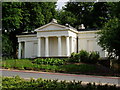
The Lodge, Mansfield Rd, Nottingham
Built 1857 as the Lodge to the racecourse, now stands at the entrance to the Forest recreation Ground. Mentioned in Pevsner.
Image: © Steve Bradwell
Taken: 15 Jul 2005
0.07 miles
9
On The Forest
The Gregory Boulevard side, looking towards Mansfield Road (and into the sun) on a bright September morning. The stone wall lost its iron railings during the War.
Image: © John Sutton
Taken: 13 Sep 2012
0.07 miles
10
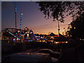
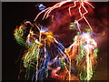
Nottingham Goose Fair
Twilight view of the one of the entrance points into the 2011 Goose Fair from Gregory Boulevard.
Image: © David Hallam-Jones
Taken: Unknown
0.07 miles