IMAGES TAKEN NEAR TO
Wiverton Road, NOTTINGHAM, NG7 6NT
Introduction
This page details the photographs taken nearby to Wiverton Road, NG7 6NT by members of the Geograph project.
The Geograph project started in 2005 with the aim of publishing, organising and preserving representative images for every square kilometre of Great Britain, Ireland and the Isle of Man.

There are currently over 7.5m images from over14,400 individuals and you can help contribute to the project by visiting https://www.geograph.org.uk
Image Map
Images are licensed for reuse under creativecommons.org/licenses/by-sa/2.0
Notes
- Clicking on the map will re-center to the selected point.
- The higher the marker number, the further away the image location is from the centre of the postcode.
Image Listing (207 Images Found)
Images are licensed for reuse under creativecommons.org/licenses/by-sa/2.0
Image
Details
Distance
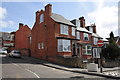
1
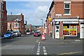
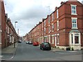
Forest Fields: the corner of Wiverton Road and Birrell Road
Houses built during the massive expansion of Nottingham in the last twenty years of the nineteenth century.
Image: © John Sutton
Taken: 6 Jul 2015
0.01 miles
2
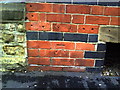
Benchmark on side wall of #102 Foxhall Road
Ordnance Survey cut mark benchmark described on the Bench Mark Database at http://www.bench-marks.org.uk/bm35197.
Image: © Roger Templeman
Taken: 10 Aug 2010
0.03 miles
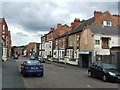
3
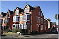
Houses at junction of Foxhall Road and Wiverton Road
There is an OS benchmark Image on the side of the end house left of the wheelie bins
Image: © Roger Templeman
Taken: 31 Mar 2013
0.03 miles
4
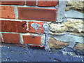
Remains of benchmark on side of #44 Leslie Road
Remaining parts of damaged Ordnance Survey cut mark benchmark which is described on the Bench Mark Database at http://www.bench-marks.org.uk/bm35198.
Image: © Roger Templeman
Taken: 10 Aug 2010
0.05 miles
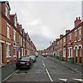
5
Junction of Leslie Road and Wiverton Road
There is a damaged OS benchmark Image on the corner of the near house at its junction with the stone wall
Image: © Roger Templeman
Taken: 31 Mar 2013
0.05 miles
7
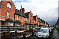
Forest Fields: Exeter Road
The Forest Fields district was built as Nottingham expanded hugely in the last decades of the nineteenth century. Terraces in these styles can be found all over the city.
Image: © John Sutton
Taken: 12 Sep 2018
0.06 miles
8
75-95 Foxhall Road, Nottingham
A relatively rare, and possibly the only extant, example of Watson Fothergill's domestic work. Built 1901. See also Image Grade II listed.
Watson Fothergill, or Fothergill Watson as he began life, is Nottingham's Victorian architectural superstar. Walking around the city, it's not long before his idiosyncratic buildings jump out. Drawing on English traditions in a style sometimes labelled as Domestic Revival, his copious use of polychromatic bands of stone, timberwork and carved detail are very distinctive. In lesser hands, a mass of features results in an overwrought jumble, but Fothergill, despite apparently never working outside Nottinghamshire, and rarely even outside the city, was clearly skilled enough to blend everything together successfully.
For a full list of his buildings, see http://www.geograph.org.uk/article/The-Buildings-of-Watson-Fothergill.
Image: © Stephen Richards
Taken: 19 Jun 2015
0.06 miles
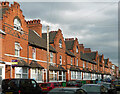
10
Foxhall Road
The picture includes nos. 65 to 95 which are three blocks of terraces built in 1901 and designed by the idiosyncratic Nottingham architect Watson Fothergill. These are probably the humblest buildings by him. Each block is separately Grade II listed.
Image: © David Lally
Taken: 12 Mar 2010
0.07 miles