IMAGES TAKEN NEAR TO
Birrell Road, NOTTINGHAM, NG7 6LT
Introduction
This page details the photographs taken nearby to Birrell Road, NG7 6LT by members of the Geograph project.
The Geograph project started in 2005 with the aim of publishing, organising and preserving representative images for every square kilometre of Great Britain, Ireland and the Isle of Man.

There are currently over 7.5m images from over14,400 individuals and you can help contribute to the project by visiting https://www.geograph.org.uk
Image Map
Images are licensed for reuse under creativecommons.org/licenses/by-sa/2.0
Notes
- Clicking on the map will re-center to the selected point.
- The higher the marker number, the further away the image location is from the centre of the postcode.
Image Listing (179 Images Found)
Images are licensed for reuse under creativecommons.org/licenses/by-sa/2.0
Image
Details
Distance
1
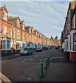
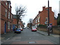
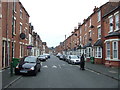
Forest Fields: Birrell Road
The red-brick suburb of Forest Fields developed in the last twenty years of the 19th century, after the expansion of the Borough to include Radford, Basford and other parishes in 1877. This is an uphill view from Berridge Road to Gladstone Street.
Image: © John Sutton
Taken: 5 Sep 2013
0.01 miles
3
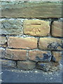
Benchmark on Gladstone Street wall
Ordnance Survey cut mark benchmark described on the Bench Mark Database at http://www.bench-marks.org.uk/bm35196
Image: © Roger Templeman
Taken: 10 Aug 2010
0.04 miles
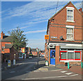
4
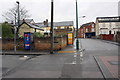
Junction on Gladstone Street and Foxhall Road
There is an OS benchmark Image near the wall angle
Image: © Roger Templeman
Taken: 9 Apr 2012
0.04 miles
6
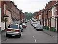
The north end of Foxhall Road
Seen from the corner of Gladstone Street. The trees in the distance are on the hillside on the other side of The Forest. Beyond the car coming up the hill Foxhall Road dips more steeply down to Gregory Boulevard. The 1:50,000 map shows the street layout here much more approximately than the 1:25,000 does.
Image: © John Sutton
Taken: 27 Apr 2011
0.04 miles
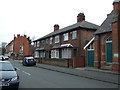
7
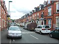
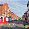
Forest Fields: the corner of Berridge Road and Birrell Road
The red-brick suburb of Forest Fields developed in the last twenty years of the 19th century, after the expansion of the Borough to include Radford, Basford and other parishes in 1877.
Image: © John Sutton
Taken: 5 Sep 2013
0.04 miles
9
Cedar Road, Sherwood Rise
Off Alberta Terrace.
Image: © JThomas
Taken: 27 Mar 2017
0.05 miles
10
Forest Fields: Cedar Road
Forest Fields developed in the last twenty years of the 19th century, after the Borough expanded in 1877. This view of typical red-brick terraced houses shows the uphill stretch between Berridge Road and Gladstone Street.
Image: © John Sutton
Taken: 5 Sep 2013
0.05 miles