IMAGES TAKEN NEAR TO
Terrace Street, NOTTINGHAM, NG7 6ER
Introduction
This page details the photographs taken nearby to Terrace Street, NG7 6ER by members of the Geograph project.
The Geograph project started in 2005 with the aim of publishing, organising and preserving representative images for every square kilometre of Great Britain, Ireland and the Isle of Man.

There are currently over 7.5m images from over14,400 individuals and you can help contribute to the project by visiting https://www.geograph.org.uk
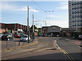
Image Map
Images are licensed for reuse under creativecommons.org/licenses/by-sa/2.0
Notes
- Clicking on the map will re-center to the selected point.
- The higher the marker number, the further away the image location is from the centre of the postcode.
Image Listing (210 Images Found)
Images are licensed for reuse under creativecommons.org/licenses/by-sa/2.0
Image
Details
Distance
1
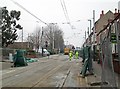
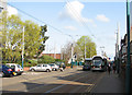
Tramway track renewal at Noel Street
The diamond where the north- and southbound lines cross was being renewed and a shuttle bus service from The Forest (behind the camera) to Wilkinson Street linked the two halves of the NET tramway. This was the last morning of the work: normal tram services were due to resume the next day.
Image: © John Sutton
Taken: 11 Apr 2013
0.01 miles
2

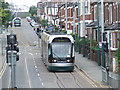
Lord Byron bound for Hucknall
Nottingham Express Transit tram 'Lord Byron' entering a single track, contra flow line section along Noel Street.
Image: © Graham Hogg
Taken: 10 Mar 2014
0.01 miles
3
Nottingham trams
Nottingham's tram network includes sections of street running as well as sections of route on segregated track.
Image: © Malc McDonald
Taken: 26 May 2008
0.02 miles
4
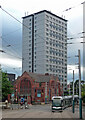
The Pinnacle, Noel Street, Nottingham
A tram has just passed an 18-storey tower block, built c1970 as Braidwood Court. It has since been re-clad and known as High Point and The Pinnacle (not sure which is current).
Image: © Stephen Richards
Taken: 19 Jun 2015
0.03 miles
5
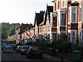
Noel Street: closed for tramway track renewal
The diamond where the north- and southbound lines cross was being renewed and a shuttle bus service from The Forest (ahead) to Wilkinson Street linked the two halves of the NET tramway. The characteristic three-storey terraced houses date from the 1880s and the rapid expansion of the borough (as the city then was).
Image: © John Sutton
Taken: 11 Apr 2013
0.03 miles
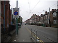
6
Tram on Noel Street
A southbound tram is turning out of Terrace Street on its way to the city centre and the Station Street terminus.
Image: © John Sutton
Taken: 16 Apr 2010
0.03 miles
7
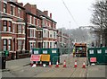
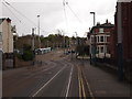
South end of Noel Street, Hyson Green
This end of Noel Street is used by Nottingham Express Transit trams in both directions; however, southbound trams only join it at the traffic lights (centre), using Terrace Street to cut across from Radford Road. Northbound trams, on the other hand, use the full length of Noel Street before turning west, meaning that trams travelling in opposite directions on the same route are over 200 yards apart for around half a mile. It also means that the northbound and southbound tracks cross one another twice.
Image: © Richard Vince
Taken: 23 Sep 2013
0.03 miles
9
Nottingham - NG5 (Forest)
A more distant view of the Gregory Boulevard/Noel Street junction and 'The Forest' tram stop.
Image: © David Hallam-Jones
Taken: 5 May 2012
0.05 miles
10
Terrace Street, Hyson Green
After leaving the Hyson Green stop, the southbound tram line snakes along Terrace Street, past Asda, to Noel Street, then crosses Gregory Boulevard to reach The Forest stop.
Image: © John Sutton
Taken: 25 Sep 2009
0.05 miles