IMAGES TAKEN NEAR TO
Field Maple Drive, NOTTINGHAM, NG7 5PU
Introduction
This page details the photographs taken nearby to Field Maple Drive, NG7 5PU by members of the Geograph project.
The Geograph project started in 2005 with the aim of publishing, organising and preserving representative images for every square kilometre of Great Britain, Ireland and the Isle of Man.

There are currently over 7.5m images from over14,400 individuals and you can help contribute to the project by visiting https://www.geograph.org.uk
Image Map
Images are licensed for reuse under creativecommons.org/licenses/by-sa/2.0
Notes
- Clicking on the map will re-center to the selected point.
- The higher the marker number, the further away the image location is from the centre of the postcode.
Image Listing (201 Images Found)
Images are licensed for reuse under creativecommons.org/licenses/by-sa/2.0
Image
Details
Distance
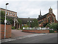
1
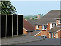
From Church to Church
Standing outside St Stephen's Church on Bobbers Mill Road and looking due west, you can see St Margaret's Church about a mile away on Aspley Lane. The houses in the foreground are on Field Maple Drive, on the slope of the Leen Valley.
Image: © John Sutton
Taken: 19 May 2010
0.02 miles
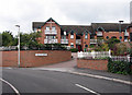
2
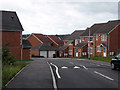
Field Maple Drive
A new development off Bobbers Mill Road, sloping down to the valley of the River Leen.
Image: © John Sutton
Taken: 3 Sep 2009
0.02 miles
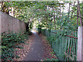
3
Plantation Side - 3
The route has become a footpath again, running next to the River Leen. The new houses of The Poplars may be seen on the right.
Image: © John Sutton
Taken: 12 Aug 2009
0.04 miles
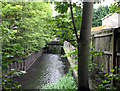
4
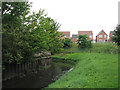
River Leen - 2
Looking towards the houses on Field Maple Drive, a recent development off Bobbers Mill Road.
Image: © John Sutton
Taken: 12 Aug 2009
0.04 miles
5
Churchside Gardens
Part of the recent developments off Bobbers Mill Road.
Image: © John Sutton
Taken: 3 Sep 2009
0.04 miles
6
St Stephen's with St Paul's and The Vine Community Centre, Bobbers Mill Road
Nikolaus Pevsner was quite taken with St Stephen's: "1897 by Christian, Caroe and Purday. It seems to be by Caroe and it is very typical of his style, with a very fanciful broad crossing turret, very low aisles with broad windows, a W front [seen here] with a naughty buttress right up the centre of the central window...and detail of the characteristic Arts and Crafts Gothic of c. 1900."
Image: © John Sutton
Taken: 3 Sep 2009
0.05 miles
7

River Leen at Bobbers Mill
The red-brick factory and chimney in the distance are part of the disused Gerard's Soap Works.
Image: © John Sutton
Taken: 16 Apr 2010
0.06 miles
8
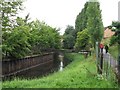
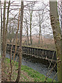
River Leen
The twitchel from Plantation Side to Gauntley Street is behind the fence.
Image: © John Sutton
Taken: 12 Aug 2009
0.06 miles
9
Plantation Side - 5
The twitchel beside the River Leen, between The Poplars and Meadow Brown Road.
Image: © John Sutton
Taken: 25 Sep 2009
0.06 miles
10
The Leen from Plantation Side
Showing flood-prevention piling and, on the other side of the river, one of several huge piles of brick rubble on the Gerard's Soap Works site. The factory was demolished in April 2011.
Image: © John Sutton
Taken: 11 Apr 2013
0.06 miles