IMAGES TAKEN NEAR TO
Brushfield Street, NOTTINGHAM, NG7 5LL
Introduction
This page details the photographs taken nearby to Brushfield Street, NG7 5LL by members of the Geograph project.
The Geograph project started in 2005 with the aim of publishing, organising and preserving representative images for every square kilometre of Great Britain, Ireland and the Isle of Man.

There are currently over 7.5m images from over14,400 individuals and you can help contribute to the project by visiting https://www.geograph.org.uk
Image Map
Images are licensed for reuse under creativecommons.org/licenses/by-sa/2.0
Notes
- Clicking on the map will re-center to the selected point.
- The higher the marker number, the further away the image location is from the centre of the postcode.
Image Listing (232 Images Found)
Images are licensed for reuse under creativecommons.org/licenses/by-sa/2.0
Image
Details
Distance
1
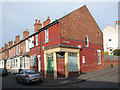
Brushfield Street: former corner shop
On the corner of Hazlewood Road.
Image: © John Sutton
Taken: 25 Sep 2009
0.01 miles
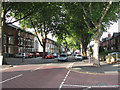
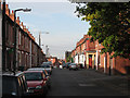
2
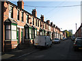
Brushfield Street
Looking towards Birkin Avenue and Hyson Green early on a brilliant September morning.
Image: © John Sutton
Taken: 24 Sep 2009
0.03 miles
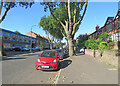
3
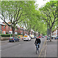
A May morning on Gregory Boulevard
Near the Alfreton Road end, looking towards Hyson Green.
Image: © John Sutton
Taken: 12 May 2014
0.04 miles
5
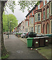
Gregory Boulevard: bins and bays
Three-storey houses typical of those built in various parts of the city in the last part of the 19th century.
Image: © John Sutton
Taken: 12 May 2014
0.05 miles
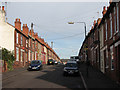
6
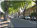
Gregory Boulevard
Near the Alfreton Road end, with a typical Nottingham three-storey terrace on the right.
Image: © John Sutton
Taken: 24 Sep 2009
0.05 miles
7
Gregory Boulevard at the end of August
Nearing the Alfreton Road end of Gregory Boulevard.
Image: © John Sutton
Taken: 30 Aug 2024
0.05 miles
8
Gregory Boulevard
From Birkin Avenue crossroads.
Image: © John Sutton
Taken: 25 Sep 2009
0.06 miles
9
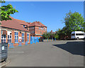
The back of Berridge Primary and Nursery School
Where I was here in the 1950s, infant classes were in the building to the left and juniors on the top floor of the larger building in the background, which fronts Berridge Road. The last few classes of Berridge Elementary for Boys were on the ground floor until the last of them left at 14, I think in the mid fifties. By then a lot of secondary-modern schools and two new grammar schools had been built to cater for the post-war bulge.
Image: © John Sutton
Taken: 5 May 2018
0.06 miles
10
Brushfield Street
Looking from the Birkin Avenue end towards Berridge Road.
Image: © John Sutton
Taken: 25 Sep 2009
0.06 miles