IMAGES TAKEN NEAR TO
Lambert Street, NOTTINGHAM, NG7 5FX
Introduction
This page details the photographs taken nearby to Lambert Street, NG7 5FX by members of the Geograph project.
The Geograph project started in 2005 with the aim of publishing, organising and preserving representative images for every square kilometre of Great Britain, Ireland and the Isle of Man.

There are currently over 7.5m images from over14,400 individuals and you can help contribute to the project by visiting https://www.geograph.org.uk
Image Map
Images are licensed for reuse under creativecommons.org/licenses/by-sa/2.0
Notes
- Clicking on the map will re-center to the selected point.
- The higher the marker number, the further away the image location is from the centre of the postcode.
Image Listing (206 Images Found)
Images are licensed for reuse under creativecommons.org/licenses/by-sa/2.0
Image
Details
Distance
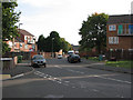
1
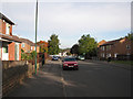
Craven Road
A housing development replacing Victorian terraces.
Image: © John Sutton
Taken: 25 Sep 2009
0.03 miles
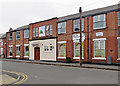
2
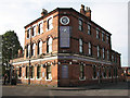
Corner Pub
A typical Victorian corner pub, on the corner of Birkin Avenue and Randal Street. Now branded The Wheel Tappers at The Clock, it was originally The Avenue, known locally as The Clock.
Image: © John Sutton
Taken: 25 Sep 2009
0.04 miles
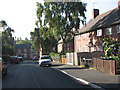
3
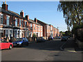
Berridge Road West
Typical mixture of terraced houses and hosiery works.
Image: © John Sutton
Taken: 25 Sep 2009
0.05 miles
4
Hovenden Gardens
A replacement for the Victorian houses of Birkin Avenue.
Image: © John Sutton
Taken: 25 Sep 2009
0.06 miles
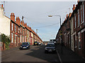
5
Berridge Road West
From the corner of Kenslow Avenue.
Image: © John Sutton
Taken: 24 Sep 2009
0.06 miles
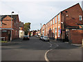
6
Randal Gardens
A housing development replacing Victorian houses on Berridge Road and Randal Street.
Image: © John Sutton
Taken: 25 Sep 2009
0.07 miles
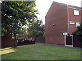
8
Berridge Road West: Bobbers Mill Community Centre
Once a small factory, this is now an Islamic centre, housing the Masjid As-Shifa mosque, a day nursery, a school, a youth club and a radio station.
Image: © John Sutton
Taken: 29 Aug 2017
0.07 miles
9
Birkin Avenue
Replacements for Victorian terraces.
Image: © John Sutton
Taken: 25 Sep 2009
0.07 miles
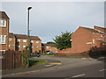
10
Kenslow Avenue
Looking towards Brushfield Street. Kenslow Avenue is the only street of inter-wars council houses in an area of Victorian terraces.
Image: © John Sutton
Taken: 24 Sep 2009
0.08 miles