IMAGES TAKEN NEAR TO
Birkin Avenue, NOTTINGHAM, NG7 5AF
Introduction
This page details the photographs taken nearby to Birkin Avenue, NG7 5AF by members of the Geograph project.
The Geograph project started in 2005 with the aim of publishing, organising and preserving representative images for every square kilometre of Great Britain, Ireland and the Isle of Man.

There are currently over 7.5m images from over14,400 individuals and you can help contribute to the project by visiting https://www.geograph.org.uk
Image Map
Images are licensed for reuse under creativecommons.org/licenses/by-sa/2.0
Notes
- Clicking on the map will re-center to the selected point.
- The higher the marker number, the further away the image location is from the centre of the postcode.
Image Listing (222 Images Found)
Images are licensed for reuse under creativecommons.org/licenses/by-sa/2.0
Image
Details
Distance
2
Hyson Green: Acourt Street
The building on the right, now a mosque, was originally, according to Robert Mellors' "Old Nottingham suburbs: then and now" (1914), a handicraft centre, one of the many council schools - including Bentinck Road, Berridge Road, Scotholme and Forster Street - built in Radford following the Forster Education Act of 1870.
Image: © John Sutton
Taken: 20 Nov 2009
0.03 miles
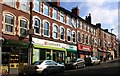
3
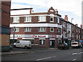
Hyson Green - the former Staddons store
Older people will remember the Staddons furnishing store and its huge clock on the Radford Road side, above the main door. The white panel above the windows on the Caulton Street facade once carried the Staddon name, in large, flourishing letters.
Image: © John Sutton
Taken: 20 Nov 2009
0.05 miles
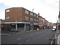
4
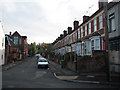
Hyson Green: on Palin Street
Looking towards Radford Road from near the corner of Hubert Street. Claypole Road rises on the other side of Radford Road.
Image: © John Sutton
Taken: 20 Nov 2009
0.06 miles
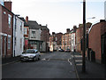
6
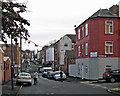
Radford Road shops in Hyson Green
Hyson Green has the largest ethnic minority population in Nottingham and this is seen in the multicultural shops on Radford Road.
Image: © Graham Hogg
Taken: 10 Mar 2014
0.07 miles
8
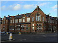
Bentinck Primary School
Former Alfreton Road School of the Nottingham Schools Board.
Image: © Alan Murray-Rust
Taken: 7 Nov 2008
0.07 miles
9
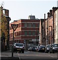
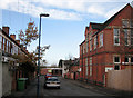
A November morning in Palin Street
A foreshortened view of the stretch of Palin Street between Birkin Avenue and Alfreton Road. Closing off the view, on the corner of Alfreton Road and Beckenham Road, is what was originally one of the more recent of the Players tobacco factories in Radford, now an office block known as New Brook House.
Image: © John Sutton
Taken: 20 Nov 2009
0.07 miles
10
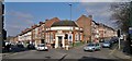
Former National Provincial Bank at corner of Radford Road and Bentinck Road
It is suggested that this may have been most recently an Indian bank, but originally it seems to have been opened by the National Provincial Bank after 1918, and became a National Westminster Bank branch after Westminster and National Provincial merged about 1967.
Image: © Chris Morgan
Taken: 10 Mar 2014
0.08 miles