IMAGES TAKEN NEAR TO
Portland Road, NOTTINGHAM, NG7 4HL
Introduction
This page details the photographs taken nearby to Portland Road, NG7 4HL by members of the Geograph project.
The Geograph project started in 2005 with the aim of publishing, organising and preserving representative images for every square kilometre of Great Britain, Ireland and the Isle of Man.

There are currently over 7.5m images from over14,400 individuals and you can help contribute to the project by visiting https://www.geograph.org.uk
Image Map
Images are licensed for reuse under creativecommons.org/licenses/by-sa/2.0
Notes
- Clicking on the map will re-center to the selected point.
- The higher the marker number, the further away the image location is from the centre of the postcode.
Image Listing (419 Images Found)
Images are licensed for reuse under creativecommons.org/licenses/by-sa/2.0
Image
Details
Distance
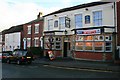
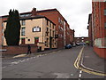
1
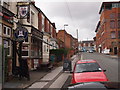
Nottingham - NG7
Portland Road is a one-way street connecting Waverley St (with access points into the Arboretum) with Alfreton Road (A610). This is the Portland Arms pub - complete with a sun blind - at the Alfreton Road end and a mill building that has been converted into residential accommodation.
Image: © David Hallam-Jones
Taken: 28 Apr 2012
0.03 miles
2
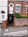
Nottingham - NG7
"Duck or Grouse"! An unusually low overhead entrance into a public alleyway that connects Portland Street (under the front door of No.28) with Cromwell Street.
Image: © David Hallam-Jones
Taken: 28 Apr 2012
0.03 miles
4
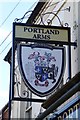
The sign of The Portland Arms
Image: © David Lally
Taken: 25 Mar 2017
0.04 miles
5
The Portland Arms
On Portland Street, just off the Alfreton Road.
A Hardy Hanson house.
Image: © David Lally
Taken: 7 Nov 2008
0.04 miles
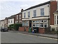
6
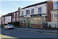
The Portland Arms
On Portland Road. Ex Kimberly's pub now (perhaps permanently) closed.
Image: © David Lally
Taken: 25 Mar 2017
0.04 miles
7
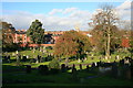
Cemetery, Cromwell Street and All Saints Church
From the General Cemetery.
Image: © David Lally
Taken: 7 Nov 2008
0.05 miles
8
Nottingham - NG7
A row of small workshops, with rooms above, in Gamble Street. In Sheffield these might be described as having belonged to (or been rented to) "little mesters", those independent, metal-working craftsmen - the little masters - of yesteryear.
Image: © David Hallam-Jones
Taken: 28 Apr 2012
0.06 miles
9
Nottingham - NG7
Looking up Raleigh Street towards Alfreton Road (A610). O'Rourkes Irish pub, that sits on the corner of Stoneleigh Street, has now become The Corner Bar.
Image: © David Hallam-Jones
Taken: 28 Apr 2012
0.06 miles
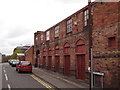
10
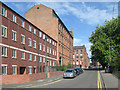
Russell Street: former lace factories
The factories of Russell, Newdigate and Gamble Streets were built after 1870, some, such as the subject of this picture, with lantern finishing rooms with large windows on the top floor (like the workshop windows of the earlier frame-knitters' cottages, but on a much grander scale). This is the former Kirk's factory (1872), now student accommodation.
See Image] for a closer view of the clock on the Newdigate Street corner.
Image: © John Sutton
Taken: 23 Aug 2013
0.06 miles