IMAGES TAKEN NEAR TO
Cromwell Street, NOTTINGHAM, NG7 4GJ
Introduction
This page details the photographs taken nearby to Cromwell Street, NG7 4GJ by members of the Geograph project.
The Geograph project started in 2005 with the aim of publishing, organising and preserving representative images for every square kilometre of Great Britain, Ireland and the Isle of Man.

There are currently over 7.5m images from over14,400 individuals and you can help contribute to the project by visiting https://www.geograph.org.uk
Image Map
Images are licensed for reuse under creativecommons.org/licenses/by-sa/2.0
Notes
- Clicking on the map will re-center to the selected point.
- The higher the marker number, the further away the image location is from the centre of the postcode.
Image Listing (414 Images Found)
Images are licensed for reuse under creativecommons.org/licenses/by-sa/2.0
Image
Details
Distance
1

Benchmark on cemetery wall on SE side of Cromwell Street
Ordnance Survey cut mark benchmark described on the Bench Mark Database at www.bench-marks.org.uk/bm111713
Image: © Luke Shaw
Taken: 14 Sep 2019
0.02 miles
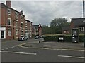
2

Cemetery wall on SE side of Cromwell Street
There is an Ordnance Survey benchmark Image on the wall on bricks 10 from the right hand edge of the image
Image: © Luke Shaw
Taken: 14 Sep 2019
0.02 miles
5

Nottingham General Cemetery: gravestones
Largely Victorian and largely slate.
Image: © John Sutton
Taken: 11 Oct 2006
0.06 miles

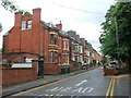
7

Cemetery wall on SE side of Cromwell Street
There is an Ordnance Survey benchmark Image cut into bricks of the wall
Image: © Luke Shaw
Taken: 14 Sep 2019
0.07 miles
8
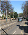
A tram in Waverley Street
A southbound tram on a bright May morning.
Image: © John Sutton
Taken: 3 May 2016
0.08 miles
9

Trams in Waverley Street
This is a much steeper hill than it looks in this picture. Modern trams make light of the climb past The Arboretum (to the right) between the Trent University stop on Goldsmith Street and the High School stop at the top of the hill.
Image: © John Sutton
Taken: 9 Sep 2010
0.08 miles
10

Nottingham General Cemetery
The section alongside Waverley Street has become home to a number of Commonwealth War Graves Commission headstones, largely additional to the names recorded on the main monument https://www.geograph.org.uk/photo/790095
The cemetery was set up in 1836 as a private company, the Nottingham General Cemetery Company, which operated until the early 1950s when it went into voluntary liquidation. It was then vested in the Crown, before being transferred to the City of Nottingham in 1956. Now a Grade II Listed Park.
Image: © Alan Murray-Rust
Taken: 26 Jul 2019
0.08 miles