IMAGES TAKEN NEAR TO
Gamble Street, NOTTINGHAM, NG7 4GE
Introduction
This page details the photographs taken nearby to Gamble Street, NG7 4GE by members of the Geograph project.
The Geograph project started in 2005 with the aim of publishing, organising and preserving representative images for every square kilometre of Great Britain, Ireland and the Isle of Man.

There are currently over 7.5m images from over14,400 individuals and you can help contribute to the project by visiting https://www.geograph.org.uk
Image Map
Images are licensed for reuse under creativecommons.org/licenses/by-sa/2.0
Notes
- Clicking on the map will re-center to the selected point.
- The higher the marker number, the further away the image location is from the centre of the postcode.
Image Listing (310 Images Found)
Images are licensed for reuse under creativecommons.org/licenses/by-sa/2.0
Image
Details
Distance
1
Nottingham - NG7
A pub situated on the corner of Newdigate Street and Gamble Street that was converted into a nightclub called "Moog" has now closed down. The spire of All Saints' Church on Raleigh Street can be seen on the horizon.
Image: © David Hallam-Jones
Taken: 28 Apr 2012
0.01 miles
2
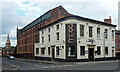
Moog Bar, Newdigate Street, Nottingham
The pub has closed since this photo.
Behind is Image], and beyond that is the spire of All Saints.
Image: © Stephen Richards
Taken: 19 Jun 2015
0.01 miles
3
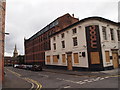
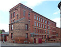
Newdigate Street: Provident Works
A typical former textile factory, now offices. The truncated chimney shows above the roof on the left.
Image: © John Sutton
Taken: 21 Jun 2017
0.01 miles
4
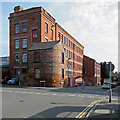
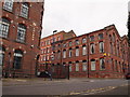
Provident Works (The Student Lodge), Gamble Street, Nottingham
Tenement lace factory of c.1860, now converted to student accommodation. The corner building housed the offices. Listed Grade II.
Image: © Alan Murray-Rust
Taken: 12 Aug 2019
0.01 miles
5
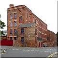
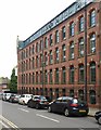
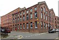
Provident Works, Newdigate Street, Nottingham
In a cluster of former industrial buildings associated with lacemaking. This flatted factory was built c1870. Grade II listed.
Like everything else, it's now student accommodation.
Image: © Stephen Richards
Taken: 19 Jun 2015
0.02 miles
6
Kirk's Factory (Nottingham Square), Newdigate Street, Nottingham
Tenement lace factory, dated 1872, now converted to student accommodation. Listed Grade II. The factory displays the typical long clerestory windows, set back from the main front, lighting lace finishing rooms.
Image: © Alan Murray-Rust
Taken: 12 Aug 2019
0.02 miles
7
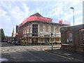
Pub demolition
This building has had a number of names since it ceased to be a traditional pub. Unfortunately I cannot remember what its name was.
Image: © David Lally
Taken: 7 Mar 2019
0.02 miles
8
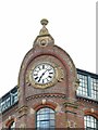
Kirk's Factory (Nottingham Square), Newdigate Street, Nottingham ? detail
Corner gable with clock and date, 1872. See http://www.geograph.org.uk/photo/6238379 for location.
Image: © Alan Murray-Rust
Taken: 12 Aug 2019
0.02 miles
9
Nottingham - NG7
"Russell Galleries", another mill conversion. This block of student accommodation on the right sits at the junction of Russell Street and Newdigate Street.
Image: © David Hallam-Jones
Taken: 28 Apr 2012
0.03 miles
10
Provident Works (Bee Living), Russell Street, Nottingham
Later 19th century extension to the Provident Works http://www.geograph.org.uk/photo/6238377 . Listed Grade II.
Image: © Alan Murray-Rust
Taken: 12 Aug 2019
0.03 miles