IMAGES TAKEN NEAR TO
Forest Road West, NOTTINGHAM, NG7 4EP
Introduction
This page details the photographs taken nearby to Forest Road West, NG7 4EP by members of the Geograph project.
The Geograph project started in 2005 with the aim of publishing, organising and preserving representative images for every square kilometre of Great Britain, Ireland and the Isle of Man.

There are currently over 7.5m images from over14,400 individuals and you can help contribute to the project by visiting https://www.geograph.org.uk
Image Map (Loading...)


Getting Data...Please wait
Leaflet Map data © OpenStreetMap
Images are licensed for reuse under creativecommons.org/licenses/by-sa/2.0
Notes
- Clicking on the map will re-center to the selected point.
- The higher the marker number, the further away the image location is from the centre of the postcode.
Image Listing (227 Images Found)
Images are licensed for reuse under creativecommons.org/licenses/by-sa/2.0
Image
Details
Distance
1
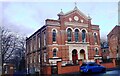
Christadelphian Church, Forest Road West
Ordnance Survey records indicate that a benchmark levelled at 74.860m above Newlyn Datum was verified in 1962 on the front of the church about 8 feet from its left hand corner. The mark appears to have been lost by the addition of a disabled access ramp
Image: © Roger Templeman
Taken: 29 Jan 2022
0.02 miles
2

Benchmark on wall fronting #58/58a Forest Road West
Ordnance Survey cut mark benchmark levelled at 75.069m above Newlyn Datum in 1986
Image: © Luke Shaw
Taken: 14 Sep 2019
0.02 miles
3
#58a/58 Forest Road West at Southey Street junction
There is an Ordnance Survey benchmark Image on the full height brick wall at its junction with a lower brick wall topped by railings
Image: © Luke Shaw
Taken: 14 Sep 2019
0.02 miles
4
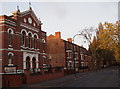
Nottingham, NG7 - Forest Road West
A Christadelphian Hall (perhaps occupying a building that was once used by another church group ?) and some terraced housing on Forest Road West.
Image: © David Hallam-Jones
Taken: 11 Nov 2012
0.03 miles
6
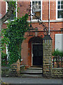
Detail of 111 Forest Road West, Nottingham
Wrought-iron overthrow with lamp (1884, by Sidney Stevenson).
Image: © Stephen Richards
Taken: 19 Jun 2015
0.03 miles
7
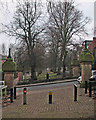
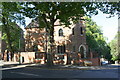
Grand gateways on Southey Street
People who like eccentric gate piers may like this picture of four at the Southey Street ends of Waterloo Promenade and Waterloo Crescent (ahead). For other views see
Image]
Image]
Image]
Image]
Image: © John Sutton
Taken: 23 Jan 2017
0.03 miles
8
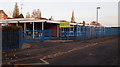
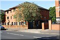
Nottingham, NG7 - Ayr Street
A fairly secure Education Authority "Learning Centre", "providing individualised education to children and young people". Its address is given as Forest Road West, although this looks like the main entrance.
Image: © David Hallam-Jones
Taken: 11 Nov 2012
0.03 miles
9
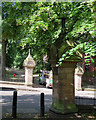
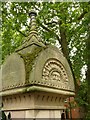
Southey Street gate piers
For a winter version, see Image
For more views of these extraordinary carved gate piers, see
Image]
Image]
Image]
Image]
Image: © John Sutton
Taken: 21 Jun 2017
0.03 miles
10
Entrance to Waterloo Promenade, Southey Street, Nottingham ? detail
Showing one of the half-faces on the cap, and the cast iron lamp support on top of the pier. See http://www.geograph.org.uk/photo/6238394 for location.
Image: © Alan Murray-Rust
Taken: 12 Aug 2019
0.03 miles