IMAGES TAKEN NEAR TO
Forest Road West, NOTTINGHAM, NG7 4EL
Introduction
This page details the photographs taken nearby to Forest Road West, NG7 4EL by members of the Geograph project.
The Geograph project started in 2005 with the aim of publishing, organising and preserving representative images for every square kilometre of Great Britain, Ireland and the Isle of Man.

There are currently over 7.5m images from over14,400 individuals and you can help contribute to the project by visiting https://www.geograph.org.uk
Image Map
Images are licensed for reuse under creativecommons.org/licenses/by-sa/2.0
Notes
- Clicking on the map will re-center to the selected point.
- The higher the marker number, the further away the image location is from the centre of the postcode.
Image Listing (171 Images Found)
Images are licensed for reuse under creativecommons.org/licenses/by-sa/2.0
Image
Details
Distance
1
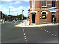
Junction of Forest Rd West with Alfreton Road
Dixy Chicken on the corner.
Image: © Roger Templeman
Taken: 10 Aug 2010
0.01 miles
2
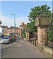
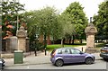
Forest Road West
The Alfreton Road end of Forest Road, with the entrance to Waterloo Promenade on the right.
For more views of these extraordinary carved gate piers, see
Image]
Image]
Image]
Image]
Image: © John Sutton
Taken: 21 Jun 2017
0.01 miles
3
Waterloo Promenade and Forest Road West
The distinctive gate piers are peculiar to this part of Nottingham - see Image], which has links to pictures of the others.
Image: © John Sutton
Taken: 23 Jan 2017
0.01 miles
4
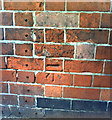
Benchmark on side of Dixy Chicken, Forest Rd West
Ordnance Survey cut mark benchmark described on the Bench Mark Database at http://www.bench-marks.org.uk/bm35154.
Image: © Roger Templeman
Taken: 10 Aug 2010
0.02 miles
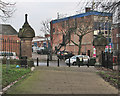
5
Entrance to Waterloo Promenade, Forest Road West, Nottingham
Waterloo Promenade was developed in the 1850s as part of improvements under the Nottingham Inclosure Act of 1845. Piers and stone copings are Listed Grade II, the railings being modern replacements for the originals which were taken for war effort scrap during WW2.
Image: © Alan Murray-Rust
Taken: 12 Aug 2019
0.02 miles
6
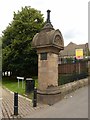
Entrance to Waterloo Promenade, Forest Road West, Nottingham ? gate pier
Waterloo Promenade was developed in the 1850s as part of improvements under the Nottingham Inclosure Act of 1845. Piers and stone copings are Listed Grade II, the railings being modern replacements for the originals which were taken for war effort scrap during WW2.
Image: © Alan Murray-Rust
Taken: 12 Aug 2019
0.02 miles
7
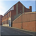
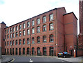
Gamble Street: Bertrand Russell House
Now student accommodation, this was originally a lace works, with north-light clerestory attic finishing rooms. The cement pattern on the end gable is a clue to the size (and chimneys) of the adjoining building which preceded the current one.
Image: © John Sutton
Taken: 21 Jun 2017
0.03 miles
8
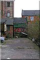
Side yard of J. B. Spray & Co.
A graffiti artist has picked a good complementary colour for his work on the green shed door.
Image: © David Lally
Taken: 6 Mar 2008
0.03 miles
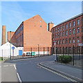
9
Albert Mill, Gamble Street, Nottingham
In a cluster of former industrial buildings associated with lacemaking. This fine building was rebuilt by Arthur Brewill in 1893. A chimney - sacrificed for this photo - survives (Image]).
Like everything else, it's now student accommodation.
Image: © Stephen Richards
Taken: 19 Jun 2015
0.05 miles
10
Gamble Street: former factories
Former lace and textile works, now student flats within easy reach of Nottingham Trent University's city-centre campus. For the other side of the one in the centre, see Image Its chimney is truncated.
Image: © John Sutton
Taken: 21 Jun 2017
0.05 miles