IMAGES TAKEN NEAR TO
Gedling Grove, NOTTINGHAM, NG7 4DU
Introduction
This page details the photographs taken nearby to Gedling Grove, NG7 4DU by members of the Geograph project.
The Geograph project started in 2005 with the aim of publishing, organising and preserving representative images for every square kilometre of Great Britain, Ireland and the Isle of Man.

There are currently over 7.5m images from over14,400 individuals and you can help contribute to the project by visiting https://www.geograph.org.uk
Image Map (Loading...)


Getting Data...Please wait
Leaflet Map data © OpenStreetMap
Images are licensed for reuse under creativecommons.org/licenses/by-sa/2.0
Notes
- Clicking on the map will re-center to the selected point.
- The higher the marker number, the further away the image location is from the centre of the postcode.
Image Listing (267 Images Found)
Images are licensed for reuse under creativecommons.org/licenses/by-sa/2.0
Image
Details
Distance
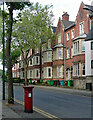
1
Gedling Grove, Nottingham
At the junction with Arthur Street.
Image: © David Lally
Taken: 6 Mar 2008
0.01 miles
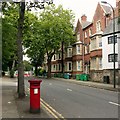
2
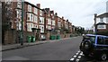
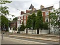
Gedling Grove
A view from the corner of Arthur Street on a bright August morning. These streets of substantial houses are part of Nottingham's first suburbs, built to the north of the city's mediaeval core in the years following the Enclosure Act of 1845.
Image: © John Sutton
Taken: 23 Aug 2013
0.01 miles
3
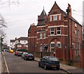
House with tower
On Gedling Grove, Nottingham. Rather strange example of the dramatic Victorian architecture in this inner suburb of the city.
I lived in this house in my 3rd year at Nottingham University and for about nine months after.
Image: © David Lally
Taken: 6 Mar 2008
0.03 miles
4
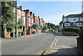
Gedling Grove, Nottingham
Several houses in Gedling Grove boast features similar to those incorporated in other buildings in Nottingham by the Victorian architect T.C. Hine (1813-99). Indeed All Saints Church, Raleigh Street, that was designed by him is only a few streets away from this one. In the distance, across Waverley St is the Arboretum and thus it seems likely that this house, and others in this street and neighbourhood were designed by well established architects as homes for wealthy families in what was once one of the formerly 'nicer parts' of the city.
Image: © David Hallam-Jones
Taken: 13 Feb 2016
0.04 miles
5
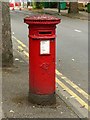
Lawson Street postbox, ref.NG7 98, Forest Road West
Standard later VR pillar box. See http://www.geograph.org.uk/photo/6238427 for location.
Image: © Alan Murray-Rust
Taken: 12 Aug 2019
0.04 miles
6
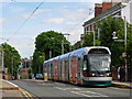
Waverley Street, Nottingham
A tram reaches the top of the steepish climb up Waverley Street to call at the High School stop. Its final destination is Hucknall.
Image: © Stephen McKay
Taken: 3 Jul 2008
0.05 miles
7
Forest Road West, Nottingham
Complete with VR pillar box http://www.geograph.org.uk/photo/6238425 .
Unusually empty of traffic, due to closure for renewal of tram tracks and junction remodelling at Mount Hooton Road, visible in the distance.
Image: © Alan Murray-Rust
Taken: 12 Aug 2019
0.05 miles
8
McIvor Terrace, Forest Road West, Nottingham
Eight houses built by a T. Fish, 1883.
Post box aficionados see Image
Image: © Stephen Richards
Taken: 19 Jun 2015
0.05 miles
9
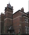
Mount Vernon Terrace, Waverley Street, Nottingham
A terrace of 4 town houses, built c.1840, the tower added c.1865 by T C Hine, the Nottingham architect, supposedly added to give a view of horse races on The Forest. Listed Grade II, the Listing referring to garden railings, most of which have been replaced by the less attractive concrete block screens.
Image: © Alan Murray-Rust
Taken: 12 Aug 2019
0.05 miles
10
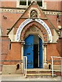
Nottinghamshire Deaf Society, Forest Road West, Nottingham ? entrance
Designed in 1867 as a theological college, hence the sculpted panel in the gable. See http://www.geograph.org.uk/photo/6238424 for fuller details.
Image: © Alan Murray-Rust
Taken: 12 Aug 2019
0.05 miles