IMAGES TAKEN NEAR TO
Mount Hooton Road, NOTTINGHAM, NG7 4AY
Introduction
This page details the photographs taken nearby to Mount Hooton Road, NG7 4AY by members of the Geograph project.
The Geograph project started in 2005 with the aim of publishing, organising and preserving representative images for every square kilometre of Great Britain, Ireland and the Isle of Man.

There are currently over 7.5m images from over14,400 individuals and you can help contribute to the project by visiting https://www.geograph.org.uk
Image Map
Images are licensed for reuse under creativecommons.org/licenses/by-sa/2.0
Notes
- Clicking on the map will re-center to the selected point.
- The higher the marker number, the further away the image location is from the centre of the postcode.
Image Listing (251 Images Found)
Images are licensed for reuse under creativecommons.org/licenses/by-sa/2.0
Image
Details
Distance
1
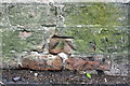
Benchmark on the wall of Mount Hooton Road
Ordnance Survey cut mark benchmark described on the Bench Mark Database at http://www.bench-marks.org.uk/bm42611
Image: © Roger Templeman
Taken: 9 Apr 2012
0.04 miles
2
Junction of Mount Hooton Road and Weston Avenue
There is an OS benchmark Image on the corner of the wall
Image: © Roger Templeman
Taken: 9 Apr 2012
0.04 miles
3
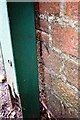
Benchmark on wall on SW side of Mount Hooton Road
Ordnance Survey cut mark benchmark described on the Bench Mark Database at www.bench-marks.org.uk/bm111706
Image: © Luke Shaw
Taken: 14 Sep 2019
0.04 miles
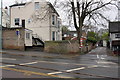
4
Nottingham tram #205 passing #1 Mount Hooton Road
Image: © Luke Shaw
Taken: 14 Sep 2019
0.04 miles
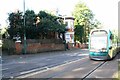
5
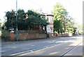
Mount Hooton Road passing #1
There is an Ordnance Survey benchmark Image on the house boundary wall behind the electricity post right of the corner wall pier
Image: © Luke Shaw
Taken: 14 Sep 2019
0.04 miles
6
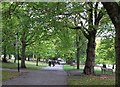
The Forest: walking to work
It's a good climb up the path parallel to Mount Hooton Road for people making their way to work in the city. They had about twenty minutes to get there for nine.
Image: © John Sutton
Taken: 15 Sep 2011
0.04 miles
8
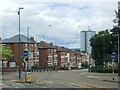
The Forest and a tram on Mount Hooton Road
Looking towards the entrance to The Forest opposite the end of Bentinck Road. A red-painted tram advertising something or other is just reaching the end of the steep section down Mount Hooton Road and is slowing to call at The Forest park-and-ride stop on Noel Street.
Image: © John Sutton
Taken: 5 Sep 2013
0.05 miles
10
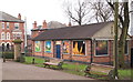
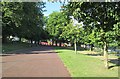
Noel Street, Nottingham
Trafalgar Lodge, the HQ of the 7th Scout & Guide Group, on the edge of The Forest recreation ground. The backdrop is provided by houses on Noel Street, a moderately steep hill that carries trams and other vehicles up and down it between the city centre (to the left) and particular suburbs and towns.
Image: © David Hallam-Jones
Taken: 13 Feb 2016
0.06 miles