IMAGES TAKEN NEAR TO
Lawson Street, NOTTINGHAM, NG7 4AW
Introduction
This page details the photographs taken nearby to Lawson Street, NG7 4AW by members of the Geograph project.
The Geograph project started in 2005 with the aim of publishing, organising and preserving representative images for every square kilometre of Great Britain, Ireland and the Isle of Man.

There are currently over 7.5m images from over14,400 individuals and you can help contribute to the project by visiting https://www.geograph.org.uk
Image Map
Images are licensed for reuse under creativecommons.org/licenses/by-sa/2.0
Notes
- Clicking on the map will re-center to the selected point.
- The higher the marker number, the further away the image location is from the centre of the postcode.
Image Listing (276 Images Found)
Images are licensed for reuse under creativecommons.org/licenses/by-sa/2.0
Image
Details
Distance
1
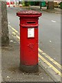
Lawson Street postbox, ref.NG7 98, Forest Road West
Standard later VR pillar box. See http://www.geograph.org.uk/photo/6238427 for location.
Image: © Alan Murray-Rust
Taken: 12 Aug 2019
0.03 miles
2
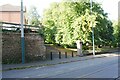
Mount Hooton Road at Waterloo Road (path) junction
There is an Ordnance Survey benchmark Image on a stone in the wall left of the lamppost near the left hand side of the image
Image: © Luke Shaw
Taken: 14 Sep 2019
0.03 miles
3
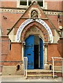
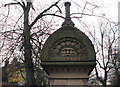
Nottinghamshire Deaf Society, Forest Road West, Nottingham ? entrance
Designed in 1867 as a theological college, hence the sculpted panel in the gable. See http://www.geograph.org.uk/photo/6238424 for fuller details.
Image: © Alan Murray-Rust
Taken: 12 Aug 2019
0.03 miles
4
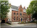
Nottinghamshire Deaf Society, Forest Road West, Nottingham
Building designed by Nottingham architect R. C. Sutton for the newly set up Paton Congressional College in 1867. The Nottingham Congregational Institute, a theological training college for Congregational Ministers, was established in Nottingham in 1866 by the Rev. J.B. Paton. From 1868 it had premises on Forest Road. Its name was changed to Paton Congregational College in around 1921. The Nottinghamshire Deaf Society took over the building in 1930 when the college moved away. Listed Grade II.
Image: © Alan Murray-Rust
Taken: 12 Aug 2019
0.03 miles
5
Waterloo Crescent: gateway
One of four grand stone gateposts either side of Mount Hooton Road, at the entrances to Waterloo Crescent and The Forest.
Image: © John Sutton
Taken: 20 Nov 2009
0.03 miles
6
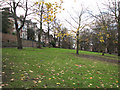
Waterloo Crescent
Seen from Mount Hooton Road.
Image: © John Sutton
Taken: 20 Nov 2009
0.04 miles
7
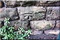
Benchmark on wall on SW side of Mount Hooton Road at Waterloo Road junction
Ordnance Survey cut mark benchmark described on the Bench Mark Database at www.bench-marks.org.uk/bm111707
Image: © Luke Shaw
Taken: 14 Sep 2019
0.04 miles
8
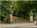
Entrance to Waterloo Promenade, Mount Hooton Road, Nottingham
One of a series of similar pairs of gate piers to the Promenade and The Forest by Henry Moses Wood, City Surveyor. Mid 19th century, Listed Grade II.
Image: © Alan Murray-Rust
Taken: 12 Aug 2019
0.04 miles
9
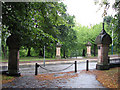
The Forest gateway, from Waterloo Crescent
There are identical grand gateposts at each end of Waterloo Crescent and Waterloo Promenade, but The Forest's, on the other side of Mount Hooton Road, are a different shape.
Image: © John Sutton
Taken: 26 Aug 2010
0.04 miles
10
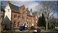
Nottinghamshire Deaf Society building
Image: © Chris Morgan
Taken: 10 Mar 2014
0.04 miles