IMAGES TAKEN NEAR TO
Waterloo Road, NOTTINGHAM, NG7 4AU
Introduction
This page details the photographs taken nearby to Waterloo Road, NG7 4AU by members of the Geograph project.
The Geograph project started in 2005 with the aim of publishing, organising and preserving representative images for every square kilometre of Great Britain, Ireland and the Isle of Man.

There are currently over 7.5m images from over14,400 individuals and you can help contribute to the project by visiting https://www.geograph.org.uk
Image Map
Images are licensed for reuse under creativecommons.org/licenses/by-sa/2.0
Notes
- Clicking on the map will re-center to the selected point.
- The higher the marker number, the further away the image location is from the centre of the postcode.
Image Listing (289 Images Found)
Images are licensed for reuse under creativecommons.org/licenses/by-sa/2.0
Image
Details
Distance
1
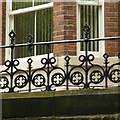
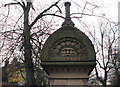
Cast-iron railings, Waterloo Road
Elaborate mid-19th century ironwork; the houses would have been sought-after by prosperous families when first built.
Image: © Alan Murray-Rust
Taken: 12 Aug 2019
0.03 miles
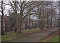
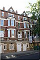
2
Waterloo Crescent
Seen from Mount Hooton Road.
Image: © John Sutton
Taken: 20 Nov 2009
0.04 miles
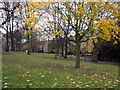
3
Waterloo Crescent on a January afternoon
Nottingham’s Victorian planners established a number of tree-lined promenades in what were then some of the most fashionable suburbs. Such walks were seen as an alternative to the “drinking shops, where, in short-lived excitement, [working men] may forget their toil, but where they waste the means of their families and too often destroy their health”.
Image]
Image]
Image]
Image]
Image: © John Sutton
Taken: 23 Jan 2017
0.05 miles
4
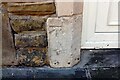
Benchmark on left hand jamb on road level door of #103 Forest Road West
Ordnance Survey cut mark benchmark described on the Bench Mark Database at www.bench-marks.org.uk/bm111708
Image: © Luke Shaw
Taken: 14 Sep 2019
0.05 miles
5
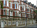
Houses on the SE side of Forest Road West
There is an Ordnance Survey benchmark Image on the left hand jamb of the road level door of #103
Image: © Luke Shaw
Taken: 14 Sep 2019
0.05 miles
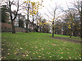
6
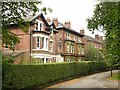
Houses on Waterloo Crescent
Mid 19th century villas on what would have been a sought-after location when built in the mid 19th century.
Image: © Alan Murray-Rust
Taken: 12 Aug 2019
0.05 miles
7
Forest Road West, Nottingham
Substantial villas and leafy streets characterise the Forest Road area between Alfreton Road and Mansfield Road. This was once a prosperous Victorian suburb - a similar district in inner London would no doubt still be considered highly desirable today. Sadly, despite its obvious attractions, this area is run down with most of the houses split into multi-occupancy dwellings and a reputation for high levels of crime. Nevertheless, this row on the south side of Forest Road manages to look impressive.
Image: © Stephen McKay
Taken: 3 Jul 2008
0.05 miles
8
Waterloo Crescent: gateway
One of four grand stone gateposts either side of Mount Hooton Road, at the entrances to Waterloo Crescent and The Forest.
Image: © John Sutton
Taken: 20 Nov 2009
0.06 miles
9
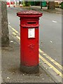
Lawson Street postbox, ref.NG7 98, Forest Road West
Standard later VR pillar box. See http://www.geograph.org.uk/photo/6238427 for location.
Image: © Alan Murray-Rust
Taken: 12 Aug 2019
0.07 miles