IMAGES TAKEN NEAR TO
Midland Way, NOTTINGHAM, NG7 3LG
Introduction
This page details the photographs taken nearby to Midland Way, NG7 3LG by members of the Geograph project.
The Geograph project started in 2005 with the aim of publishing, organising and preserving representative images for every square kilometre of Great Britain, Ireland and the Isle of Man.

There are currently over 7.5m images from over14,400 individuals and you can help contribute to the project by visiting https://www.geograph.org.uk
Image Map
Images are licensed for reuse under creativecommons.org/licenses/by-sa/2.0
Notes
- Clicking on the map will re-center to the selected point.
- The higher the marker number, the further away the image location is from the centre of the postcode.
Image Listing (149 Images Found)
Images are licensed for reuse under creativecommons.org/licenses/by-sa/2.0
Image
Details
Distance
1
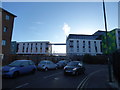
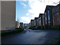
Scene near the apartment blocks on New Road, Radford, Nottingham
After a frosty night the early morning is bright, sunny and very fresh!
Image: © Jeremy Bolwell
Taken: 19 Jan 2020
0.04 miles
2
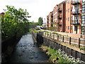
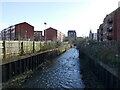
River Leen at Old Radford
Hilditch Way runs beside the flats. St Peter's Street, where Skill's bus garage and the old St Peter's Workhouse used to be, is off to the left. Older Nottinghamians will remember Skill's pale-green private-hire coaches and their offices and toy shop on Alfreton Road, at the top of Peveril Street.
Image: © John Sutton
Taken: 19 May 2010
0.05 miles
5
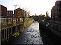
The River Leen, Radford
Looking downstream. A lost opportunity for some decent landscaping around recent housing.
Image: © Jonathan Thacker
Taken: 26 Feb 2024
0.06 miles
6
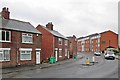
Old Radford: a wet morning in St Peter's Street
A view from the corner of Hartley Road and New Road. Formerly an exclusively working-class district of terraced streets, textile factories and workshops of various kinds, Old Radford is now home to a lot of student accommodation like the flats to the right.
Image: © John Sutton
Taken: 2 Jun 2015
0.08 miles
8
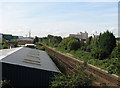
South from New Bridge
A modern railway notice calls this bridge over the Nottingham-Mansfield-Worksop line Folly Lane Bridge, but to me it will always be New Bridge. Modern industrial units cover the former Radford goods yard and the colliery sidings on the left, and beyond them are student flats; the red building in the distance left of centre is International House on the Nottingham University Jubilee Campus; the distinctive Player's Bonded Warehouse is on the skyline on the right. Radford Junction, where the line to Trowell Junction and the Erewash Valley Line diverges to the right, is hidden by trees, as is Robert Shaw Playing Field. To take the picture I stood on the part of the bridge under which the colliery sidings, long gone, once passed.
Image: © John Sutton
Taken: 27 Aug 2010
0.08 miles
9
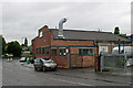
Old Radford: workshop on St Peter's Street
Bennett's Designers & Cabinet Makers Ltd at the corner of St Peter's Street and Hartley Road, photographed on a wet June morning. The security gates on the right are on the site of Radford Workhouse, a picturesque brick building completed in 1732 but not considered worth saving when it was demolished c 1970. For more about it, and a picture, see http://www.nottsheritagegateway.org.uk/themes/poverty.htm .
Image: © John Sutton
Taken: 2 Jun 2015
0.08 miles
10
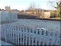
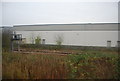
Scene at the railway adjacent to Midland Road, Radford, Nottingham
Frosted railings and trackside.
Image: © Jeremy Bolwell
Taken: 19 Jan 2020
0.08 miles