IMAGES TAKEN NEAR TO
Old Mill Close, NOTTINGHAM, NG7 3JZ
Introduction
This page details the photographs taken nearby to Old Mill Close, NG7 3JZ by members of the Geograph project.
The Geograph project started in 2005 with the aim of publishing, organising and preserving representative images for every square kilometre of Great Britain, Ireland and the Isle of Man.

There are currently over 7.5m images from over14,400 individuals and you can help contribute to the project by visiting https://www.geograph.org.uk
Image Map
Images are licensed for reuse under creativecommons.org/licenses/by-sa/2.0
Notes
- Clicking on the map will re-center to the selected point.
- The higher the marker number, the further away the image location is from the centre of the postcode.
Image Listing (150 Images Found)
Images are licensed for reuse under creativecommons.org/licenses/by-sa/2.0
Image
Details
Distance
1
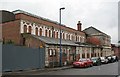
Nottingham - NG7
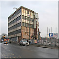
Forest Mill on Thackeray Street - off Alfreton Road (A610) - still awaiting demolition.
Image: © David Hallam-Jones
Taken: 28 Apr 2012
0.05 miles
2
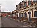
Former Baths buildings, Thackeray Street
This range of buildings was more or less attached to the Forest Mills complex, and appeared to be part of it. However, recently paint has started peeling on the part of the building with the two-storey facade, revealing the lettering 'Gentlemen's Baths and Ladies' Baths'. The fate of the building is unknown.
Image: © Alan Murray-Rust
Taken: 22 Jun 2007
0.06 miles
3
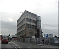
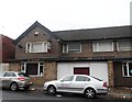
Partially Demolished Building - Nottingham
Image: © Anthony Parkes
Taken: 31 Oct 2013
0.06 miles
4
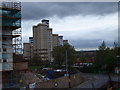
Nottingham - NG7
A mixture of the old and the new. The demolition of the High Cross Court flats on Clifford Street on the left-hand side of this picture looks well under way. The flats were condemned by fire safety experts some time ago as being unsafe for occupation. Nottingham City Council faced a £1.1 million bill to renovate them to the required safety standards and so they opted to have them demolished instead. Further modern apartments appear nearby in this wet April morning scene.
Image: © David Hallam-Jones
Taken: 28 Apr 2012
0.06 miles
5
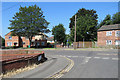
Radford: Denman Street East and Diversity Way
The Victorian street pattern in New Radford disappeared with slum clearance years ago. Denman Street once ran from St Peter's Street almost to Canning Circus, but the section ahead is now a path (in Nottingham a twitchel), Diversity Way.
Image: © John Sutton
Taken: 28 Jun 2018
0.06 miles
7
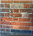
Benchmark on side of Dixy Chicken, Forest Rd West
Ordnance Survey cut mark benchmark described on the Bench Mark Database at http://www.bench-marks.org.uk/bm35154.
Image: © Roger Templeman
Taken: 10 Aug 2010
0.07 miles
8
On Alfreton Road
Between Boden Street and Highurst Street.
Image: © John Sutton
Taken: 23 Jan 2017
0.07 miles
9
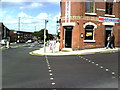
Junction of Forest Rd West with Alfreton Road
Dixy Chicken on the corner.
Image: © Roger Templeman
Taken: 10 Aug 2010
0.08 miles
10
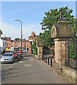
Forest Road West
The Alfreton Road end of Forest Road, with the entrance to Waterloo Promenade on the right.
For more views of these extraordinary carved gate piers, see
Image]
Image]
Image]
Image]
Image: © John Sutton
Taken: 21 Jun 2017
0.09 miles