IMAGES TAKEN NEAR TO
Bastion Street, NOTTINGHAM, NG7 3FD
Introduction
This page details the photographs taken nearby to Bastion Street, NG7 3FD by members of the Geograph project.
The Geograph project started in 2005 with the aim of publishing, organising and preserving representative images for every square kilometre of Great Britain, Ireland and the Isle of Man.

There are currently over 7.5m images from over14,400 individuals and you can help contribute to the project by visiting https://www.geograph.org.uk
Image Map
Images are licensed for reuse under creativecommons.org/licenses/by-sa/2.0
Notes
- Clicking on the map will re-center to the selected point.
- The higher the marker number, the further away the image location is from the centre of the postcode.
Image Listing (181 Images Found)
Images are licensed for reuse under creativecommons.org/licenses/by-sa/2.0
Image
Details
Distance
2
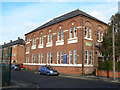
Forster Street: Radford Methodist Church
The church was designed by the Nottingham architect R C Sutton. A foundation stone beneath the blue notice board was "Laid on behalf of the sewing class by Mrs Smith". Another records the names of the Superintendent, Rev T Granger, the architect and the contractor, Mr W Savage. There has been only one slight external change since Alan Murray-Rust recorded the building on a brighter day in 2008: Image
Image: © John Sutton
Taken: 8 Jul 2015
0.04 miles
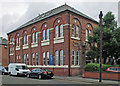
4
Radford Methodist Church
The white panels are inscribed Methodist Sunday Schools 1890, so it is clear that the church has moved in at a later stage. It is now shared with commercial occupants.
Image: © Alan Murray-Rust
Taken: 7 Nov 2008
0.05 miles
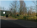
5
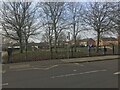
Denman Street West
During 1970s redevelopment this section of the street was converted to a pedestrian walkway, partly to reduce through traffic.
Image: © Alan Murray-Rust
Taken: 7 Nov 2008
0.05 miles
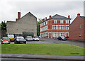
7
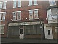
Ruchis Nursery World, Denham Street Central
This shop had stood derelict for some time at this point. It has since been converted into two houses.
Image: © Bryn Holmes
Taken: 17 Feb 2019
0.07 miles
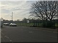
8
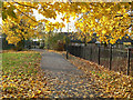
Leafy Radford
Radford Boulevard, near Denman Street corner, looking towards Alfreton Road and Gregory Boulevard. Castle, Lenton, Radford and Gregory Boulevards, laid out in the 1880s, were a piece of enlightened town planning, forming an early ring road, lined with genteel villas and some industrial premises, on the west side of the city.
Image: © John Sutton
Taken: 21 Jul 2012
0.07 miles
9
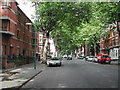
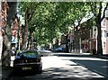
Radford Boulevard, Nottingham
in Victorian times a very fashionable area of Nottingham. Not so now, but still nice with all the trees.
Image: © Tom Courtney
Taken: 9 Sep 2005
0.07 miles
10
Old Radford: the bottom of Denman Street
The large building to the right of centre, on the corner of Rifle Street, is a lost pub, the Dover Castle, now flats. Until the 1960s the central section of Denman Street was a thriving shopping street.
Image: © John Sutton
Taken: 2 Jun 2015
0.08 miles