IMAGES TAKEN NEAR TO
Target Street, NOTTINGHAM, NG7 3EY
Introduction
This page details the photographs taken nearby to Target Street, NG7 3EY by members of the Geograph project.
The Geograph project started in 2005 with the aim of publishing, organising and preserving representative images for every square kilometre of Great Britain, Ireland and the Isle of Man.

There are currently over 7.5m images from over14,400 individuals and you can help contribute to the project by visiting https://www.geograph.org.uk
Image Map
Images are licensed for reuse under creativecommons.org/licenses/by-sa/2.0
Notes
- Clicking on the map will re-center to the selected point.
- The higher the marker number, the further away the image location is from the centre of the postcode.
Image Listing (181 Images Found)
Images are licensed for reuse under creativecommons.org/licenses/by-sa/2.0
Image
Details
Distance
1
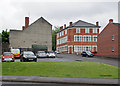
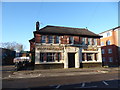
Old Radford: the bottom of Denman Street
The large building to the right of centre, on the corner of Rifle Street, is a lost pub, the Dover Castle, now flats. Until the 1960s the central section of Denman Street was a thriving shopping street.
Image: © John Sutton
Taken: 2 Jun 2015
0.03 miles
2
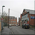
Radford: a grey morning in Croydon Road
The three-strorey building ahead, on the corner of Rifle Street, is now flats, but was originally a pub, The Dover Castle.
Image: © John Sutton
Taken: 12 Apr 2016
0.04 miles
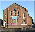
3

Old Radford: Evangelical Church and Bramcote Street
The chapel was built as the Methodist Free Church in 1878. It has some fairly typical Nottingham terra cotta decoration on the gable end.
Image: © John Sutton
Taken: 2 Jun 2015
0.06 miles
5
On St Peter's Street
Long before the industrial revolution, when Radford was a village and not an inner-city suburb, this was the village street - which accounts for its being alone among straight streets of terraced houses in having bends. Turentek Architectural Ironmongery Ltd is on the right, at the bottom of Denman Street.
Image: © John Sutton
Taken: 5 May 2018
0.06 miles
6
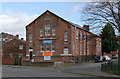
Evangelical Free Church, St Peter's Street
Built in 1878 as a United Methodist Free Church chapel.
Image: © Alan Murray-Rust
Taken: 16 Feb 2014
0.07 miles
8
The Nottingham Brewery
Must pop in one day.
Image: © Jeremy Bolwell
Taken: 19 Jan 2020
0.07 miles
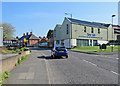
10
Denman Street West
During 1970s redevelopment this section of the street was converted to a pedestrian walkway, partly to reduce through traffic.
Image: © Alan Murray-Rust
Taken: 7 Nov 2008
0.08 miles