IMAGES TAKEN NEAR TO
Lonsdale Road, NOTTINGHAM, NG7 3DU
Introduction
This page details the photographs taken nearby to Lonsdale Road, NG7 3DU by members of the Geograph project.
The Geograph project started in 2005 with the aim of publishing, organising and preserving representative images for every square kilometre of Great Britain, Ireland and the Isle of Man.

There are currently over 7.5m images from over14,400 individuals and you can help contribute to the project by visiting https://www.geograph.org.uk
Image Map
Images are licensed for reuse under creativecommons.org/licenses/by-sa/2.0
Notes
- Clicking on the map will re-center to the selected point.
- The higher the marker number, the further away the image location is from the centre of the postcode.
Image Listing (176 Images Found)
Images are licensed for reuse under creativecommons.org/licenses/by-sa/2.0
Image
Details
Distance
1
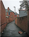
A Radford twitchel
A gloomy April morning in Old Radford. This twitchel links Hartley Road to Lonsdale Road (ahead).
Image: © John Sutton
Taken: 12 Apr 2016
0.03 miles
2
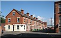
Forster Street
A typical Radford street. The house on the corner was once a shop. Alan Murray-Rust's Image] shows the other side of the street. This view would once have been dominated by the Hartley Road end of Players cigarette factory, long since demolished and now the site of the retail park visible in the distance.
Image: © John Sutton
Taken: 21 Jul 2012
0.04 miles
3
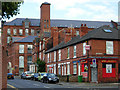
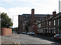
Hartley Road, Radford
Seen here at the junction with Lonsdale Road. The large mill building ahead is Boulevard works, once the home of Marathon Knitwear; it is now student accommodation.
Image: © Stephen McKay
Taken: 3 Jul 2008
0.04 miles
4
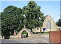
Radford church gate
A view from Hartley Road across the corner of Churchfield Lane. St Peter's is a very plain early 19th-century church with a High Victorian chancel.
Image: © John Sutton
Taken: 21 Jul 2012
0.04 miles
5
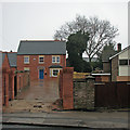
Radford: a new house on Hartley Road
The house to the right is to be demolished and a number of new houses built on the site. The picture was taken on a glum rainy morning in early spring.
Image: © John Sutton
Taken: 12 Apr 2016
0.04 miles
6
Hartley Road, Radford
This view, taken from the corner of Churchfield Lane, is dominated by the former Boulevard Works, now student accommodation.
Image: © John Sutton
Taken: 27 Aug 2010
0.04 miles
7
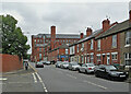
Radford: up Hartley Road
Looking towards Radford Boulevard from the corner of Churchfield Lane. The former Boulevard Works, now student accommodation, dominates the skyline.
Image: © John Sutton
Taken: 25 Aug 2021
0.04 miles
8
Rear of an old converted cotton mill in Radford, Nottingham
Now it is student accommodation believe.
Image: © Jeremy Bolwell
Taken: 19 Jan 2020
0.05 miles
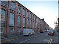
9
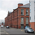
The Forster Street side of Boulevard Works
This section of the huge factory once occupied by Meridian Knitwear dates from 1896. The larger original section of 1883 faces Radford Boulevard (see Image] and others).
Now students flats, both parts of the factory are Grade II listed: http://www.britishlistedbuildings.co.uk/en-489827-boulevard-works-#.VZ2cIiiwHZY .
Image: © John Sutton
Taken: 8 Jul 2015
0.05 miles
10
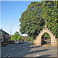
Hartley Road and St Peter's Church gate
St Peter's Church's arched gateway was rebuilt in 1953 to mark the Coronation.
Image: © John Sutton
Taken: 25 Sep 2015
0.05 miles