IMAGES TAKEN NEAR TO
Chettles Trade Park, Midland Way, NOTTINGHAM, NG7 3AG
Introduction
This page details the photographs taken nearby to Chettles Trade Park, Midland Way, NG7 3AG by members of the Geograph project.
The Geograph project started in 2005 with the aim of publishing, organising and preserving representative images for every square kilometre of Great Britain, Ireland and the Isle of Man.

There are currently over 7.5m images from over14,400 individuals and you can help contribute to the project by visiting https://www.geograph.org.uk
Image Map
Images are licensed for reuse under creativecommons.org/licenses/by-sa/2.0
Notes
- Clicking on the map will re-center to the selected point.
- The higher the marker number, the further away the image location is from the centre of the postcode.
Image Listing (151 Images Found)
Images are licensed for reuse under creativecommons.org/licenses/by-sa/2.0
Image
Details
Distance
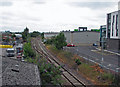
1
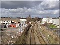
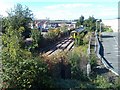
Radford Junction
The left hand line leads to Trowell Junction on the Erewash Valley Line. Once used by express services between London and Sheffield via Nottingham, it was earmarked for possible closure towards the end of the 20th century. It has revived since then, carrying the Northern Trains local service linking Nottingham, Sheffield and Leeds.
The line straight ahead is the former Midland Railway Leen Valley line, opened in 1849 to tap the expanding Nottinghamshire coalfield. Passenger services were withdrawn in the 1960s under the Beeching Plan, but were revived in 1993 as the Robin Hood Line, which now operates half-hourly between Nottingham and Mansfield Woodhouse, hourly to Worksop.
Image: © Alan Murray-Rust
Taken: 16 Feb 2014
0.03 miles
3
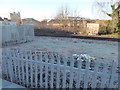
Scene at the railway adjacent to Midland Road, Radford, Nottingham
Frosted railings and trackside.
Image: © Jeremy Bolwell
Taken: 19 Jan 2020
0.04 miles
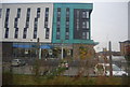
4
Nottingham 1
Student accommodation alongside the River Leen in Radford.
Image: © Alan Murray-Rust
Taken: 16 Feb 2014
0.05 miles
6
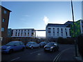
Scene near the apartment blocks on New Road, Radford, Nottingham
After a frosty night the early morning is bright, sunny and very fresh!
Image: © Jeremy Bolwell
Taken: 19 Jan 2020
0.06 miles
9
The site of Radford Station
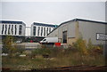
Radford Station closed in 1964 when passenger services between Nottingham, Mansfield and Worksop were withdrawn (I was on the last train), only to be reinstated as The Robin Hood Line thirty years later. The small red-brick booking office was at road level, just to the right of the camera position, and wooden covered stairways led down to the platforms. The land to the right of the tracks, now occupied by industrial units and the Opal 1 student flats (Image]) was once a large railway goods yard, from whose sidings Player's cigarettes were despatched in rail containers brought by lorry from the factories on nearby Churchfield Lane and Radford Boulevard. Older Radfordians will remember that the streets to the west of the station (left) were once locally known as Sodom.
At Radford Junction, in the middle distance, the Radford-Trowell line swings to the left and the Leen Valley line to Mansfield goes straight on. The Trowell line was opened in 1875 and enabled trains to and from the north to avoid the bottlenecks at Trent and Toton. Until the 1960s it was the route of the Edinburgh to St Pancras Waverley Express. The principal traffic on the Mansfield line, though, was coal from the Leen Valley pits, the first of which was Radford (closed 1961), whose sidings were half a mile to the north, beyond New Bridge.
Image: © John Sutton
Taken: 12 Jul 2011
0.07 miles
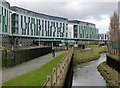
10

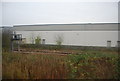
Student Roost Deakins Place
A 700 bed complex of student apartments alongside the River Leen nears completion. This is just the latest of many in this area, with two more under construction either side of Triumph Road a few hundred metres South.
Image: © SK53
Taken: 14 Jul 2022
0.08 miles