IMAGES TAKEN NEAR TO
Friar Street, NOTTINGHAM, NG7 2NU
Introduction
This page details the photographs taken nearby to Friar Street, NG7 2NU by members of the Geograph project.
The Geograph project started in 2005 with the aim of publishing, organising and preserving representative images for every square kilometre of Great Britain, Ireland and the Isle of Man.

There are currently over 7.5m images from over14,400 individuals and you can help contribute to the project by visiting https://www.geograph.org.uk
Image Map
Images are licensed for reuse under creativecommons.org/licenses/by-sa/2.0
Notes
- Clicking on the map will re-center to the selected point.
- The higher the marker number, the further away the image location is from the centre of the postcode.
Image Listing (391 Images Found)
Images are licensed for reuse under creativecommons.org/licenses/by-sa/2.0
Image
Details
Distance
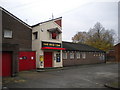
1
The Red Cow, Lenton Lane
Looking almost more like industrial premises than a pub. It is a 1970s replacement for an earlier pub.
Image: © Alan Murray-Rust
Taken: 23 Apr 2012
0.03 miles
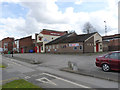
2
The Red Cow, Lenton
Located on Gregory Street, this is one of Nottingham's more eccentric looking pubs, and the only one I can recall with a three dimensional sign. The architecture, as well as the red painted doors, put me in mind of a fire station.
Image: © Richard Vince
Taken: 16 Nov 2013
0.03 miles
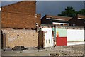
3
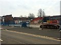
The Red Cow is demolished
See: http://www.geograph.org.uk/search.php?i=61464081 .
Image: © David Lally
Taken: 27 Feb 2016
0.03 miles
4
Old Church Street, New Lenton, Nottingham
Although difficult to see clearly, immediately to the right of the metal bollard, and behind the waist-high fence on the right, is the base of a stone pillar base occupying its original position in a grassed area. This is the only surviving a remnant of the ancient C12th Lenton Priory. The pillar is thought to have formed part of a heated common room used by the monks. Ahead, at the end of this very short path, is the corner of Priory Street and Old Church Street. The castellated house in the distance is the side of an early C19th property known now as Nazareth House. It has been known in the past as “The Priory” and “Priory House”. A certain William Stretton built this house in 1802. After his death, his son Severus Stretton, sold the property to the Congregation of the Poor Sisters of Nazareth who ministered to children (in a children’s home) and to the elderly in a combined religious and care ‘complex’ between 1880-2002. The Priory Church of St Anthony in Old Church Street is a minute's walk away behind the photographer.
Image: © David Hallam-Jones
Taken: 30 Jan 2016
0.03 miles
5
Non-motorised section of Old Church Street
The section of road next to the junction with Priory Street is a segregated path for cycles and pedestrians.
Image: © David Lally
Taken: 21 Apr 2016
0.03 miles
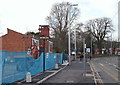
6
Open-air urinals
Following the demolition of the Red Cow. One wonders if the neighbours knew where these were in relation to their backyard wall!
Image: © David Lally
Taken: 24 Jun 2016
0.04 miles
7
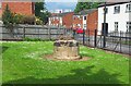
Lenton Priory
All that remains of what was once one of the greatest and most important religious houses in the Midlands is the base of a Norman column. It contrasts sharply with the surrounding buildings and even more so with the high rise blocks in the distance in the centre of Nottingham.
Image: © Garth Newton
Taken: 4 Jun 2002
0.04 miles
8
Old Church Street, New Lenton, Nottingham
Old Church Street joins Lenton Lane 25 yds ahead. This is a view of the Priory Church of St Anthony. Whilst most of the church dates from 1883 it nonetheless incorporates elements of the former chapel of the monastic hospital of Lenton Priory. The chancel dates from c.1108.
Image: © David Hallam-Jones
Taken: 30 Jan 2016
0.04 miles
9
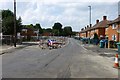
Gregory Street
The tarmac around the previously laid track looks very patchy (unlike similar sections elsewhere). Pherhaps that will be relaid (again!) before completion.
Image: © David Lally
Taken: 8 Aug 2014
0.04 miles
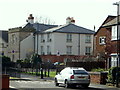
10
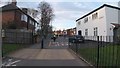
Lenton Lane, Nottingham
The site of the former Red Cow public house with a glimpse of the Priory Church of St Anthony beyond the second lamp post (from the camera lens). A red-glowing traffic light identifies where the A6005 crosses Lenton Lane. Trams run along the centre of this road, parallel with the blue security fencing, connecting Toton (ahead) and Nottingham (behind the photographer).
Image: © David Hallam-Jones
Taken: 30 Jan 2016
0.04 miles