IMAGES TAKEN NEAR TO
Dunkirk Road, NOTTINGHAM, NG7 2LF
Introduction
This page details the photographs taken nearby to Dunkirk Road, NG7 2LF by members of the Geograph project.
The Geograph project started in 2005 with the aim of publishing, organising and preserving representative images for every square kilometre of Great Britain, Ireland and the Isle of Man.

There are currently over 7.5m images from over14,400 individuals and you can help contribute to the project by visiting https://www.geograph.org.uk
Image Map
Images are licensed for reuse under creativecommons.org/licenses/by-sa/2.0
Notes
- Clicking on the map will re-center to the selected point.
- The higher the marker number, the further away the image location is from the centre of the postcode.
Image Listing (163 Images Found)
Images are licensed for reuse under creativecommons.org/licenses/by-sa/2.0
Image
Details
Distance
4
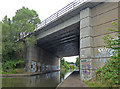
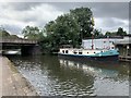
A52 Clifton Boulevard Road Bridge No 13b
Crossing the Nottingham & Beeston Canal, in the Dunkirk area of Nottingham.
Image: © Mat Fascione
Taken: 22 Jul 2015
0.03 miles
5
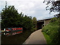
Llamedos widebeam boat
On the Nottingham and Beeston canal.
Image: © Andrew Abbott
Taken: 11 Aug 2019
0.03 miles

10
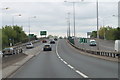
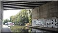
A52 eastbound, sliproad from A6005 joins
Image: © J.Hannan-Briggs
Taken: 14 May 2013
0.05 miles