IMAGES TAKEN NEAR TO
Hill Side, NOTTINGHAM, NG7 2HP
Introduction
This page details the photographs taken nearby to Hill Side, NG7 2HP by members of the Geograph project.
The Geograph project started in 2005 with the aim of publishing, organising and preserving representative images for every square kilometre of Great Britain, Ireland and the Isle of Man.

There are currently over 7.5m images from over14,400 individuals and you can help contribute to the project by visiting https://www.geograph.org.uk
Image Map
Images are licensed for reuse under creativecommons.org/licenses/by-sa/2.0
Notes
- Clicking on the map will re-center to the selected point.
- The higher the marker number, the further away the image location is from the centre of the postcode.
Image Listing (153 Images Found)
Images are licensed for reuse under creativecommons.org/licenses/by-sa/2.0
Image
Details
Distance
3
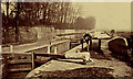
No 4 Lock Nottingham Canal near Wollaton
A very old image, taken early in the 1900s by A.W.Bird. This shows No 5 Lock with the long wall enclosing Wollaton Park running along left hand bank. Although not visible here, the gasometers of the Radford Gas works are visible through the mist to the top right. A rustic scene now completely vanished beneath modern buildings. For a modern image of the same area see Image
Image: © A.W.Bird
Taken: Unknown
0.04 miles
4
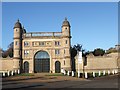
Lenton Lodge, Derby Road, Nottingham
Built 1820s, Grade II listed, former gatehouse to Wollaton Park. Now completely separated from the Park by a dual carriageway and housing
Image: © Tim Heaton
Taken: 11 Nov 2012
0.05 miles
5
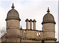
Pepper and salt?
Turrets and chimneys on the central part of Lenton (Wollaton Hall) Lodge http://www.geograph.org.uk/photo/3844286
Image: © Alan Murray-Rust
Taken: 9 Feb 2014
0.05 miles
6
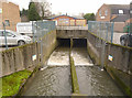
River Leen at Derby Road
The river has been entirely reconstructed in this area, much now being culverted in the immediate vicinity. Although water flow seems quite strong, the depths which have been achieved are clearly shown by the scour marks along the concrete walls.
Image: © Alan Murray-Rust
Taken: 9 Feb 2014
0.05 miles
7
River Leen bridge, Derby Road
From the bridge, the river looks like this http://www.geograph.org.uk/photo/3844292 . There is a bench mark http://www.geograph.org.uk/photo/3845538 on the face of the parapet.
Image: © Alan Murray-Rust
Taken: 9 Feb 2014
0.05 miles
8
Lenton Lodge, Derby Road
Formerly a gateway to Wollaton Park.
Image: © Andrew Abbott
Taken: 24 Jul 2010
0.05 miles
9
Bench mark, Derby Road culvert over the River Leen
See http://www.geograph.org.uk/photo/3845542 for location.
Image: © Alan Murray-Rust
Taken: 9 Feb 2014
0.06 miles
10
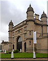
Lenton Lodge
This is the former gatehouse to Wollaton Hall, facing towards Nottingham. Designed by Sir Jeffrey Wyattville for the 6th Lord Middleton in 1823 in Elizabethan style to match the Hall itself. It is now in use as offices. Listed Grade II*, the listing also includes the bollards and chains.
Image: © Alan Murray-Rust
Taken: 9 Feb 2014
0.06 miles