IMAGES TAKEN NEAR TO
Rothesay Avenue, NOTTINGHAM, NG7 1PU
Introduction
This page details the photographs taken nearby to Rothesay Avenue, NG7 1PU by members of the Geograph project.
The Geograph project started in 2005 with the aim of publishing, organising and preserving representative images for every square kilometre of Great Britain, Ireland and the Isle of Man.

There are currently over 7.5m images from over14,400 individuals and you can help contribute to the project by visiting https://www.geograph.org.uk
Image Map
Images are licensed for reuse under creativecommons.org/licenses/by-sa/2.0
Notes
- Clicking on the map will re-center to the selected point.
- The higher the marker number, the further away the image location is from the centre of the postcode.
Image Listing (161 Images Found)
Images are licensed for reuse under creativecommons.org/licenses/by-sa/2.0
Image
Details
Distance
1
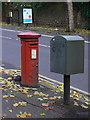
Edwardian Pillar box
E VII R box on Derby Road at Kimbolton Avenue
Image: © Alan Murray-Rust
Taken: 7 Nov 2008
0.05 miles
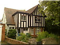
2
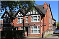
254-256 Derby Road, Nottingham
A pair of Edwardian houses.
Image: © Andrew Abbott
Taken: 25 May 2020
0.06 miles
3
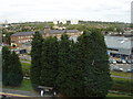
Nottingham Vista
View taken from ward D55 (Coronary Care Unit) on the 3rd floor of the Queen's Medical Centre, Nottingham, 4 days after my heart attack. The long brick building with a disused clock tower on the middle left is, according to one of the nurses on the ward, the old Bell Fruits factory, where old-style fruit machine used to be made (now converted into flats).
Image: © Oxymoron
Taken: 10 Sep 2008
0.06 miles
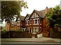
5
Harrington Drive, off Derby Road
The houses are modern additions to what is otherwise an essentially early 20th century street. There is a bench mark http://www.geograph.org.uk/photo/3845546 to the left of the black gatepost.
Image: © Alan Murray-Rust
Taken: 9 Feb 2014
0.07 miles
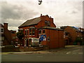
8
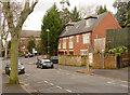
Ashburnham Avenue
Radford Recreation Ground on the left.
Image: © Alan Murray-Rust
Taken: 16 Feb 2014
0.09 miles
9
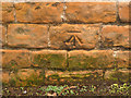
Bench mark, Harrington Drive
See http://www.geograph.org.uk/photo/3845549 for location.
Image: © Alan Murray-Rust
Taken: 9 Feb 2014
0.09 miles
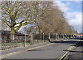
10
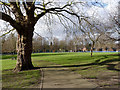
Radford Recreation Ground
View from the south east corner. There are a number of these very gnarly plane trees in the park.
Image: © Alan Murray-Rust
Taken: 16 Feb 2014
0.09 miles