IMAGES TAKEN NEAR TO
Holles Crescent, NOTTINGHAM, NG7 1BZ
Introduction
This page details the photographs taken nearby to Holles Crescent, NG7 1BZ by members of the Geograph project.
The Geograph project started in 2005 with the aim of publishing, organising and preserving representative images for every square kilometre of Great Britain, Ireland and the Isle of Man.

There are currently over 7.5m images from over14,400 individuals and you can help contribute to the project by visiting https://www.geograph.org.uk
Image Map
Images are licensed for reuse under creativecommons.org/licenses/by-sa/2.0
Notes
- Clicking on the map will re-center to the selected point.
- The higher the marker number, the further away the image location is from the centre of the postcode.
Image Listing (305 Images Found)
Images are licensed for reuse under creativecommons.org/licenses/by-sa/2.0
Image
Details
Distance
1
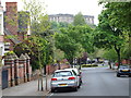
Nottingham - NG1 (Park)
Park Drive links Newcastle Circus - the circular turfed park behind the photographer - with the roundabout just ahead. The castle can be seen in the distance in the Standard Hill area of the city.
Image: © David Hallam-Jones
Taken: 18 May 2012
0.02 miles
2
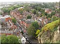
The Park, Nottingham
The Park area of Nottingham, as seen from Nottingham Castle.
Image: © Dave Pickersgill
Taken: 11 Oct 2013
0.02 miles
3
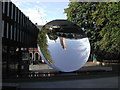
Sky Mirror
Located outside the Nottingham Playhouse and created by artist Anish Kapoor, it reflects the sky in all its moods.
Image: © Tom Courtney
Taken: 17 Sep 2005
0.02 miles
4
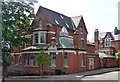
1 Cavendish Crescent South, Nottingham
By Thomas Chambers Hine, 1877, in a quasi-Queen Anne style.
Image: © Stephen Richards
Taken: 19 Jun 2012
0.03 miles
5
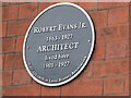
Plaque to Robert Evans Junior (architect)
On Park Ravine facade of 21 Lenton Road, Ravine House, designed by his father Robert Evans Senior and Thomas Hine and built around 1862. It was occupied by family members until around 1980.
Image: © El Loco
Taken: 2 Jan 2021
0.06 miles
6
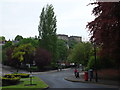
Nottingham - NG1 (Park)
A view of the roundabout between Park Drive and Peveril Drive with Tattershall Drive joining it from the left and Lenton Road leaving it on the right. The white, partially timbered building peeping out from the garden housing the extremely tall Lombardy Poplar tree is "The Registered Office of the Nottingham Park Estate Ltd" company. Once again the castle is visible.
Image: © David Hallam-Jones
Taken: 18 May 2012
0.06 miles
7
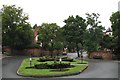
A junction in The Park
Park Drive is ahead, Lenton Road to the left, Tattershall Drive to the right and Peveril Drive behind the camera. David Hallam-Jones's Image] is the view along Peveril Drive towards the Castle.
Image: © John Sutton
Taken: 26 Aug 2010
0.07 miles
8
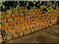
Eroded sandstone wall, Tattershall Drive
This stone looks as if it has been quarried from the nearby Castle Rock.
Image: © Stephen Craven
Taken: 18 Jan 2020
0.07 miles
9
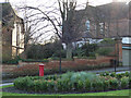
Pillar box at the top of Peveril Drive
Looking across the roundabout Image
Image: © Stephen Craven
Taken: 18 Jan 2020
0.08 miles
10
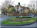
Roundabout at the top of Peveril Drive
This is a five-way junction. Note the non-standard "keep left" sign. The finger posts point not to distant destinations but local facilities (railway station, castle, tennis & squash courts, etc.)
Image: © Stephen Craven
Taken: 18 Jan 2020
0.09 miles