IMAGES TAKEN NEAR TO
Cedar Lodge, Tunnel Road, NOTTINGHAM, NG7 1BP
Introduction
This page details the photographs taken nearby to Cedar Lodge, Tunnel Road, NG7 1BP by members of the Geograph project.
The Geograph project started in 2005 with the aim of publishing, organising and preserving representative images for every square kilometre of Great Britain, Ireland and the Isle of Man.

There are currently over 7.5m images from over14,400 individuals and you can help contribute to the project by visiting https://www.geograph.org.uk
Image Map
Images are licensed for reuse under creativecommons.org/licenses/by-sa/2.0
Notes
- Clicking on the map will re-center to the selected point.
- The higher the marker number, the further away the image location is from the centre of the postcode.
Image Listing (369 Images Found)
Images are licensed for reuse under creativecommons.org/licenses/by-sa/2.0
Image
Details
Distance
1
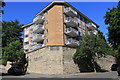
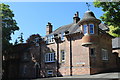
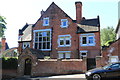
Cedar Lodge
By J. Enniss & Co, 1964-67.
Image: © Andrew Abbott
Taken: 25 May 2020
0.01 miles
2
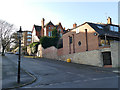
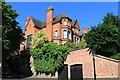
Eclectic architecture, Tunnel Road, Nottingham
A large Victorian villa half way up the hill, with much newer designs of housing before and behind.
Image: © Stephen Craven
Taken: 18 Jan 2020
0.01 miles
3
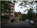
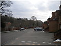
Nottingham - NG1 (Park)
The increasing need for new housing, and the desire for new housing within this prestigious estate, led to the substantial loss of gardens and the construction of a large number of infill properties between 1960-80. Their insensitive siting, inappropriate scale and the dearth of architectural merit has led, many would argue, to adverse results upon the character of this unique estate. Here a block of flats can be seen at the intersection of the Tunnel Road with Cavendish Road North. Two minutes walk further down this hill is "The Bowl", the recreational area housing several tennis clubs and a bowling club.
Image: © David Hallam-Jones
Taken: 18 May 2012
0.01 miles
4
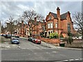
Cavendish Crescent North
From Tunnel Road.
Image: © Andrew Abbott
Taken: 18 Feb 2023
0.01 miles
5
Penrhyn Cottage
On Cavendish Road East.
Image: © Andrew Abbott
Taken: 25 May 2020
0.02 miles
6
24 Cavendish Crescent North
A house dating from ca. 1885
Image: © Andrew Abbott
Taken: 25 May 2020
0.03 miles
7
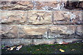
Benchmark on wall of #15 Cavendish Crescent North
Ordnance Survey cut mark benchmark described on the Bench Mark Database at http://www.bench-marks.org.uk/bm69769
Image: © Roger Templeman
Taken: 15 Aug 2015
0.03 miles
8
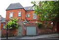
#15 Cavendish Crescent North
There is an OS benchmark Image on the stone wall right of the lamppost
Image: © Roger Templeman
Taken: 15 Aug 2015
0.04 miles
9
19 Cavendish Crescent North
A house dating from 1885.
Image: © Andrew Abbott
Taken: 25 May 2020
0.05 miles
10
Tattershall Drive, The Park
Looking south east along Tattershall Drive as it passes Nottingham Castle Lawn Tennis Club, with its namesake building visible on the horizon to the right of the bare tree.
Image: © Richard Vince
Taken: 28 Mar 2013
0.06 miles