IMAGES TAKEN NEAR TO
Cavendish Road East, NOTTINGHAM, NG7 1BB
Introduction
This page details the photographs taken nearby to Cavendish Road East, NG7 1BB by members of the Geograph project.
The Geograph project started in 2005 with the aim of publishing, organising and preserving representative images for every square kilometre of Great Britain, Ireland and the Isle of Man.

There are currently over 7.5m images from over14,400 individuals and you can help contribute to the project by visiting https://www.geograph.org.uk
Image Map
Images are licensed for reuse under creativecommons.org/licenses/by-sa/2.0
Notes
- Clicking on the map will re-center to the selected point.
- The higher the marker number, the further away the image location is from the centre of the postcode.
Image Listing (330 Images Found)
Images are licensed for reuse under creativecommons.org/licenses/by-sa/2.0
Image
Details
Distance
1
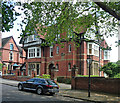
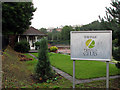
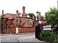
33 Cavendish Road East, Nottingham
One of The Park's larger houses, by Stockdale Harrison, 1898. The usual Victorian assemblage of detail but well composed.
Image: © Stephen Richards
Taken: 19 Jun 2012
0.01 miles
2
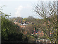
Across The Park
A view across The Park, from Newcastle Drive, with Ratcliffe on Soar power station in the distance.
Image: © John Sutton
Taken: 16 Apr 2010
0.04 miles
3
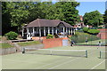
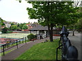
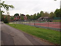
Park Tennis Club
Part of the Park Estate.
Image: © Andrew Abbott
Taken: 25 May 2020
0.04 miles
4
The Park and the power station
A view between houses on Park Terrace, across the wooded Park and, further, the Trent Valley, with Ratcliffe-on-Soar Power Station on the skyline in the centre. The picture, from the top of the sandstone ridge, gives some idea of how much higher Park Terrace and Newcastle Drive are than the rest of The Park.
Image: © John Sutton
Taken: 26 May 2014
0.05 miles
5
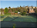
The Park Tennis Club
The grand houses at the Canning Circus end of The Ropewalk are on the skyline. When I was young The Park Tennis Club was the Nottingham epicentre of unattainable poshness.
Image: © John Sutton
Taken: 26 Aug 2010
0.05 miles
6
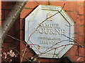
Plaque to Samuel Bourne (photographer)
On right hand face of Adam House, Clumber Road East in The Park Estate, Nottingham. Partially obscured by tree.
Image: © El Loco
Taken: 2 Jan 2021
0.05 miles
7
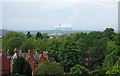
Nottingham - NG1 (Park)
A number of the private tennis club courts that are situated within "The Bowl", a recreational area in the sector of the Park Estate nearest to the castle and the city. This is the view as seen from Tattershall Drive with the Clare Valley area - in the centre of the skyline and to the left of this picture. Ramps would obviously make accessing the bowling greens and other recreational facilities (out of sight) a lot easier for less mobile users.
Image: © David Hallam-Jones
Taken: 18 May 2012
0.06 miles
8
Tennis courts, Tattershall Drive
One of at least six courts at this private club.
Image: © Stephen Craven
Taken: 18 Jan 2020
0.06 miles
9
Nottingham - NG1 (Park)
A view along the stretch of Clare Valley that runs parallel with the area known as "The Bowl" containing the courts of two private tennis clubs and the green of a private bowling club. The houses in the distance are situated on the main stretch of Clare Valley.
Image: © David Hallam-Jones
Taken: 18 May 2012
0.08 miles
10
Nottingham - NG1 (Park)
A view of the rear of a large house in Clare Valley taken from a branch of the same road. The area inside the railings is referred to as "The Bowl", an area of green space housing the courts and greens of several tennis and bowling clubs.
Image: © David Hallam-Jones
Taken: 18 May 2012
0.08 miles