IMAGES TAKEN NEAR TO
Brora Road, NOTTINGHAM, NG6 9HT
Introduction
This page details the photographs taken nearby to Brora Road, NG6 9HT by members of the Geograph project.
The Geograph project started in 2005 with the aim of publishing, organising and preserving representative images for every square kilometre of Great Britain, Ireland and the Isle of Man.

There are currently over 7.5m images from over14,400 individuals and you can help contribute to the project by visiting https://www.geograph.org.uk
Image Map
Images are licensed for reuse under creativecommons.org/licenses/by-sa/2.0
Notes
- Clicking on the map will re-center to the selected point.
- The higher the marker number, the further away the image location is from the centre of the postcode.
Image Listing (15 Images Found)
Images are licensed for reuse under creativecommons.org/licenses/by-sa/2.0
Image
Details
Distance
1

Cantrell Road
The black S-Max is emerging from Warrington Road. NCN route 6 also does that.
Image: © David Lally
Taken: 27 Apr 2017
0.11 miles
2

Nos. 306 and 304 St Albans Road
There is an OS benchmark Image on the wall pier to the left of the two gateposts
Image: © Roger Templeman
Taken: 28 Nov 2017
0.13 miles
3
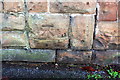
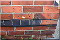
Benchmark on wall post between Nos 306 and 308 St Albans Road
Ordnance Survey cut mark benchmark described on the Bench Mark Database at http://www.bench-marks.org.uk/bm91703
Image: © Roger Templeman
Taken: 28 Nov 2017
0.13 miles
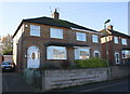
4

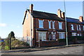
Semi detached houses on Warrington Road
Image: © Roger Templeman
Taken: 28 Nov 2017
0.15 miles
5
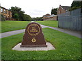
Memorial to PC Ged Walker
Memorial stone to a police officer killed whilst on duty in 2003 [http://news.bbc.co.uk/1/hi/england/nottinghamshire/4286340.stm].
Image: © Oxymoron
Taken: 4 Sep 2008
0.18 miles
6
Semi detached houses on Northolme Avenue
Image: © Roger Templeman
Taken: 28 Nov 2017
0.19 miles
7
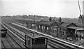
Bulwell Common Station
View southwards, towards Nottingham (Victoria); ex-Great Central 'London Extension' main line, (Annesley) - Nottingham - Leicester (Central) - Marylebone, closed (down to Quainton Road and Aylesbury) 5/9/66. This station was closed on 4/3/63, just four months before the photograph. (There is no trace of the railway there 45 years later).
Image: © Ben Brooksbank
Taken: 12 Jul 1963
0.21 miles
8
Benchmark on #112 St Albans Road
Ordnance Survey cut mark benchmark described on the Bench Mark Database at http://www.bench-marks.org.uk/bm91700
Image: © Roger Templeman
Taken: 28 Nov 2017
0.22 miles
9
St Albans Villas (Nos. 112 &110 St Albans Road)
There is an OS benchmark Image on the side of the nearest house at its front corner
Image: © Roger Templeman
Taken: 28 Nov 2017
0.22 miles
10
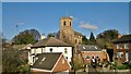
Church of St. Mary the Virgin and All Souls, Bulwell
Image: © Chris Morgan
Taken: 10 Mar 2014
0.24 miles