IMAGES TAKEN NEAR TO
Ingram Road, NOTTINGHAM, NG6 9GP
Introduction
This page details the photographs taken nearby to Ingram Road, NG6 9GP by members of the Geograph project.
The Geograph project started in 2005 with the aim of publishing, organising and preserving representative images for every square kilometre of Great Britain, Ireland and the Isle of Man.

There are currently over 7.5m images from over14,400 individuals and you can help contribute to the project by visiting https://www.geograph.org.uk
Image Map (Loading...)


Getting Data...Please wait
Leaflet Map data © OpenStreetMap
Images are licensed for reuse under creativecommons.org/licenses/by-sa/2.0
Notes
- Clicking on the map will re-center to the selected point.
- The higher the marker number, the further away the image location is from the centre of the postcode.
Image Listing (11 Images Found)
Images are licensed for reuse under creativecommons.org/licenses/by-sa/2.0
Image
Details
Distance
1
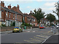
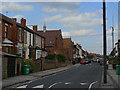
Piccadilly, Bulwell
Note the change in housing style from late Victorian terrace to inter-war semi-detached as you move further from the main Highbury Road (behind the camera).
Image: © Alan Murray-Rust
Taken: 27 Aug 2009
0.13 miles
2
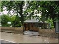
Bulwell Tram Depot
The old back wall of the tram depot can be seen over the blue and white fencing. Built for the electric trams in 1901, it was subsequently used by trolleybuses and finally motorbuses before being sold by Nottingham City Transport in around 2002. The site is now being developed for housing.
Image: © Alan Murray-Rust
Taken: 27 Aug 2009
0.19 miles
3
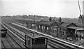
Bulwell Common Station
View southwards, towards Nottingham (Victoria); ex-Great Central 'London Extension' main line, (Annesley) - Nottingham - Leicester (Central) - Marylebone, closed (down to Quainton Road and Aylesbury) 5/9/66. This station was closed on 4/3/63, just four months before the photograph. (There is no trace of the railway there 45 years later).
Image: © Ben Brooksbank
Taken: 12 Jul 1963
0.19 miles
4
Broomhill Road
Development is this area, Highbury Vale, was stimulated by the coming of the electric tram to Bulwell.
Image: © Alan Murray-Rust
Taken: 27 Aug 2009
0.20 miles
5
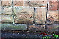
Benchmark on wall post between Nos 306 and 308 St Albans Road
Ordnance Survey cut mark benchmark described on the Bench Mark Database at http://www.bench-marks.org.uk/bm91703
Image: © Roger Templeman
Taken: 28 Nov 2017
0.20 miles
6

Nos. 306 and 304 St Albans Road
There is an OS benchmark Image on the wall pier to the left of the two gateposts
Image: © Roger Templeman
Taken: 28 Nov 2017
0.21 miles
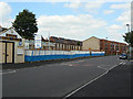
7
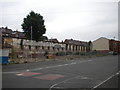
Site of Bulwell bus garage
Located on Piccadilly, just off Highbury Road about half a mile south east of Bulwell town centre, the bus garage here was previously a trolleybus depot, and before that a tram depot. If memory serves, it was closed by Nottingham City Transport in 2000; however, redevelopment of the site has been fairly slow. Since the housing visible on the extreme right was constructed, nothing much seems to have happened here.
Image: © Richard Vince
Taken: 11 Jun 2013
0.21 miles
8

Bulwell Common
The trees and houses to the left of the common are on the site of Bulwell Common Station and its associated goods and carriage sidings, built by the Great Central Railway in 1898. The station closed to passengers in 1963 and to all traffic in 1968. It is now hard to imagine there was ever a main line running north through Bulwell.
Image: © John Sutton
Taken: 6 May 2011
0.21 miles
9
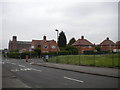
Brooklyn Road, Highbury Vale
Looking towards the junction with Kersall Drive (on which the typical inter war Nottingham council houses are situated) from opposite a small park. Further along Brooklyn Road, the church of Our Lady of Perpetual Succour can be seen.
Image: © Richard Vince
Taken: 11 Jun 2013
0.22 miles