IMAGES TAKEN NEAR TO
Brooklyn Road, NOTTINGHAM, NG6 9EE
Introduction
This page details the photographs taken nearby to Brooklyn Road, NG6 9EE by members of the Geograph project.
The Geograph project started in 2005 with the aim of publishing, organising and preserving representative images for every square kilometre of Great Britain, Ireland and the Isle of Man.

There are currently over 7.5m images from over14,400 individuals and you can help contribute to the project by visiting https://www.geograph.org.uk
Image Map
Images are licensed for reuse under creativecommons.org/licenses/by-sa/2.0
Notes
- Clicking on the map will re-center to the selected point.
- The higher the marker number, the further away the image location is from the centre of the postcode.
Image Listing (23 Images Found)
Images are licensed for reuse under creativecommons.org/licenses/by-sa/2.0
Image
Details
Distance
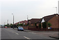
1
Saxondale Drive, Basford
Looking north east from the junction with Brooklyn Road. The houses are typical of inter war council housing in Nottingham.
Image: © Richard Vince
Taken: 11 Jun 2013
0.06 miles
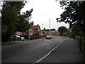
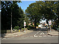
3
Brooklyn Road, Highbury Vale
Looking towards the junction with Kersall Drive (on which the typical inter war Nottingham council houses are situated) from opposite a small park. Further along Brooklyn Road, the church of Our Lady of Perpetual Succour can be seen.
Image: © Richard Vince
Taken: 11 Jun 2013
0.12 miles
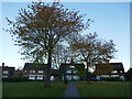
5
Saxondale Drive
Residential road off Highbury Road.
Image: © Alan Murray-Rust
Taken: 27 Aug 2009
0.18 miles
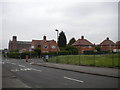
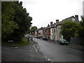
6
St Albans Road
The houses to the east of St Albans Road, and the closes behind them, are built on what was from 1898-1968 the site of the station and carriage and goods sidings at Bulwell Common, on the main line from Nottingham Victoria to Sheffield and Manchester. The secondary line which linked the Great Northern line at Basford North Station and Bulwell Common passed under the road roughly where I stood to take this picture.
Image: © John Sutton
Taken: 6 May 2011
0.18 miles
7
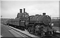
The 17.18 Nottingham (Victoria) to Derby (Friargate) service at Basford North
View eastward, towards Daybrook, Nottingham etc.; ex-Great Northern, Grantham - Nottingham - Derby line. The locomotive is LMS Ivatt 4MT 2-6-0 No. 43059. See Image for details about the line.
Image: © Ben Brooksbank
Taken: 21 Aug 1963
0.19 miles
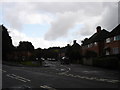
8
Park Lane, Basford
Looking north from the south eastern end of Brooklyn Road.
Image: © Richard Vince
Taken: 11 Jun 2013
0.20 miles
9
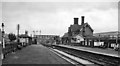
Basford North (former Basford & Bulwell) Station
View eastward, towards Nottingham (Victoria), Colwick etc. and Grantham. Basford & Bulwell station only became 'Basford North' on 21/9/53; it was closed on 7/9/64 to passengers, along with the service from Derby (Friargate) etc. (goods 4/9/67). Beyond the station can be seen Park Lane Bridge, beyond which was the bridge carrying the main ex-Great Central line from Sheffield (Victoria) to Nottingham and the South. Trains through this station to/from Nottingham Victoria joined the main line at Bagthorpe Junction by connections either side of this bridge. A curve to the left just beyond the end of the Up (left) platform connected at Bulwell South Junction with the main line towards Sheffield. The lines straight ahead led to Leen Valley Junction and by the Daybrook Loop ('Back Line') round the north side of Nottingham to the great Colwick Yards and the main line to Grantham; the Back Line lost its meagre passenger services after the partial collapse of Mapperley Tunnel on 4/4/60, although Goods continued until 1/6/64. The GC main line effectively ceased as a through route on 5/9/66 and Nottingham Victoria closed on 5/7/67.
Image: © Ben Brooksbank
Taken: 21 Aug 1963
0.20 miles
10

The site of Basford North Station
This view westwards from the former railway bridge on Park Lane shows the industrial units built on what was from 1878-1968 Basford North railway station, on the Great Northern Railway line from Nottingham to Derby Friargate, a line built principally to carry coal from Erewash Valley pits to the marshalling yard at Colwick for onward despatch. Ben Brooksbank's Image] shows the station from the west, looking towards here, in the days of steam.
Image: © John Sutton
Taken: 6 May 2011
0.20 miles