IMAGES TAKEN NEAR TO
Golf Close, NOTTINGHAM, NG6 8YZ
Introduction
This page details the photographs taken nearby to Golf Close, NG6 8YZ by members of the Geograph project.
The Geograph project started in 2005 with the aim of publishing, organising and preserving representative images for every square kilometre of Great Britain, Ireland and the Isle of Man.

There are currently over 7.5m images from over14,400 individuals and you can help contribute to the project by visiting https://www.geograph.org.uk
Image Map (Loading...)


Getting Data...Please wait
Leaflet Map data © OpenStreetMap
Images are licensed for reuse under creativecommons.org/licenses/by-sa/2.0
Notes
- Clicking on the map will re-center to the selected point.
- The higher the marker number, the further away the image location is from the centre of the postcode.
Image Listing (12 Images Found)
Images are licensed for reuse under creativecommons.org/licenses/by-sa/2.0
Image
Details
Distance
2
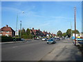
Bulwell - Grindon Crescent Junction with Hucknall Lane (A6002)
Image: © Alan Heardman
Taken: 21 Oct 2007
0.17 miles
3
Bulwell - Layton Road Junction with Hucknall Lane (A6002)
Image: © Alan Heardman
Taken: 21 Oct 2007
0.19 miles
4
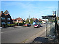
Hucknall Lane - Lawton Drive Bus Stop
Image: © Alan Heardman
Taken: 21 Oct 2007
0.21 miles
5
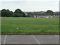
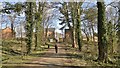
Bulwell Hall Park
The Bulwell Hall estate was taken over by Nottingham City Council and developed as recreational space, including a golf course and this cricket field.
Image: © Alan Murray-Rust
Taken: 27 Aug 2009
0.22 miles
6
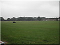
Bulwell Cricket Grounds
Recreating this 'First' for the square https://www.geograph.org.uk/photo/49357 .
The cricket facility appears to have disappeared by about 2011, with play equipment encroaching on what had been the square.
Image: © Alan Murray-Rust
Taken: 19 Jul 2022
0.22 miles
7
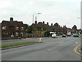
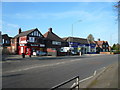
Hucknall Lane
The houses are part of a large inter-war council housing estate popularly known as Chinatown due to the amount of pottery found there.
Image: © Alan Murray-Rust
Taken: 27 Aug 2009
0.22 miles
8
Bulwell Cricket Grounds
It also had a nice Clubhouse until the vandals did their nasty work
Image: © Tom Courtney
Taken: 5 Sep 2005
0.23 miles
9
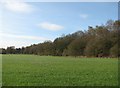
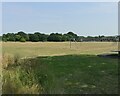
Great Central Railway embankment
The overgrown embankment of the Great Central main line from Manchester and Sheffield to London Marylebone (1899-1966), just north of Bulwell Hall Estate. Houses on Longford Crescent are on the far left of the picture.
Image: © John Sutton
Taken: 6 Apr 2012
0.24 miles
10
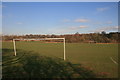
Bring your own nets
One of several football pitches in Bulwell Hall Park
Image: © Graham Hogg
Taken: 10 Mar 2014
0.24 miles