IMAGES TAKEN NEAR TO
Widdowson Close, NOTTINGHAM, NG6 8WB
Introduction
This page details the photographs taken nearby to Widdowson Close, NG6 8WB by members of the Geograph project.
The Geograph project started in 2005 with the aim of publishing, organising and preserving representative images for every square kilometre of Great Britain, Ireland and the Isle of Man.

There are currently over 7.5m images from over14,400 individuals and you can help contribute to the project by visiting https://www.geograph.org.uk
Image Map (Loading...)


Getting Data...Please wait
Leaflet Map data © OpenStreetMap
Images are licensed for reuse under creativecommons.org/licenses/by-sa/2.0
Notes
- Clicking on the map will re-center to the selected point.
- The higher the marker number, the further away the image location is from the centre of the postcode.
Image Listing (16 Images Found)
Images are licensed for reuse under creativecommons.org/licenses/by-sa/2.0
Image
Details
Distance
1
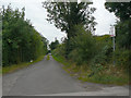
Off Blenheim Lane
The notice points to the small Blenheim Farm caravan campsite.
Image: © Alan Murray-Rust
Taken: 27 Aug 2009
0.04 miles
2
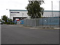
Blenheim Industrial Estate
The Co-op food distribution centre on Freeston Drive
Image: © Oxymoron
Taken: 11 Aug 2008
0.08 miles
3

Blenheim Industrial Estate: Hi-loaders
The shape of these hi-loaders against the sky is as good as a modern sculpture.
Image: © Oxymoron
Taken: 11 Aug 2008
0.09 miles
5
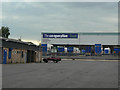
The Co-operative food
This is a large regional distribution centre on Blenheim Industrial Estate.
Image: © Alan Murray-Rust
Taken: 27 Aug 2009
0.12 miles
6
Blenheim Lane, near Bulwell (2)
Looking towards Blenheim Industrial Estate and Bulwell from the Nottingham city boundary.
Image: © Richard Vince
Taken: 16 Nov 2013
0.14 miles
7

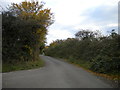
Blenheim Lane, near Bulwell (1)
This part of Blenheim Lane is basically a farm access road, but it also hosts a public bridleway.
Image: © Richard Vince
Taken: 16 Nov 2013
0.15 miles
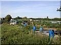
8
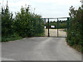
Allotment gate
Part of the extensive Blenheim Allotments.
Image: © Alan Murray-Rust
Taken: 27 Aug 2009
0.15 miles
9
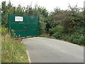
Long Distance footpath
The dark hole to the right of the gate is part of the Robin Hood Way long distance footpath.
Image: © Alan Murray-Rust
Taken: 27 Aug 2009
0.15 miles
10
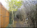
Footpath off Blenheim Lane
The Robin Hood Way is tucked away between allotments (right) and some sort of agricultural premises (left) as it heads north east from Blenheim Lane.
Image: © Richard Vince
Taken: 16 Nov 2013
0.16 miles