IMAGES TAKEN NEAR TO
Hill Road, NOTTINGHAM, NG6 8TJ
Introduction
This page details the photographs taken nearby to Hill Road, NG6 8TJ by members of the Geograph project.
The Geograph project started in 2005 with the aim of publishing, organising and preserving representative images for every square kilometre of Great Britain, Ireland and the Isle of Man.

There are currently over 7.5m images from over14,400 individuals and you can help contribute to the project by visiting https://www.geograph.org.uk
Image Map (Loading...)


Getting Data...Please wait
Leaflet Map data © OpenStreetMap
Images are licensed for reuse under creativecommons.org/licenses/by-sa/2.0
Notes
- Clicking on the map will re-center to the selected point.
- The higher the marker number, the further away the image location is from the centre of the postcode.
Image Listing (46 Images Found)
Images are licensed for reuse under creativecommons.org/licenses/by-sa/2.0
Image
Details
Distance
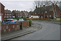
1
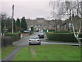
Bestwood Village, Coronation Road
The name gives a clue to the date of building. Typical post-war council development with only a narrow carriageway - council tenants were not expected to own motor cars! At this stage the colliery was still productive and modern housing was important.
Image: © Alan Murray-Rust
Taken: 13 Jan 2008
0.05 miles
2
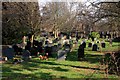
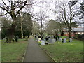
Bestwood Village cemetery
The cemetery is associated with the nearby St Marks Church
Image: © Graham Hogg
Taken: 10 Mar 2014
0.07 miles
4
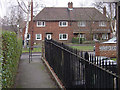
Bestwood Village, The Spinney
The Robin Hood Way emerges into this quiet cul-de-sac
Image: © Alan Murray-Rust
Taken: 13 Jan 2008
0.08 miles
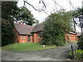
5
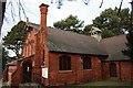
St. Mark's Church
Built in 1887. Another of the many buildings in the village which distinctive style indicates it was built by the colliery owners, the Bestwood Coal and Iron Company for the benefit of their employees.
Image: © Mick Garratt
Taken: 5 Jan 2008
0.09 miles
6
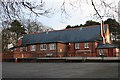
Hawthorne Primary School
Another of the many buildings in the village which distinctive style indicates it was built by the colliery owners, the Bestwood Coal and Iron Company for the benefit of their employees.
Image: © Mick Garratt
Taken: 5 Jan 2008
0.09 miles
7
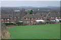
Bestwood Village, The Spinney
This is the most northern extension to the village and probably dates from the 1960s. This is the view looking west towards Hucknall.
Image: © Alan Murray-Rust
Taken: 13 Jan 2008
0.09 miles
8
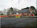
The former Hawthorne Primary School and Nursery
Replaced with newer buildings on a nearby site.
Image: © Jonathan Thacker
Taken: 31 Mar 2022
0.09 miles
10
St, Mark's church, Bestwood Village
Designed by J. Medland Taylor https://manchestervictorianarchitects.org.uk/architects/james-medland-taylor 1886-7.
Image: © Jonathan Thacker
Taken: 31 Mar 2022
0.10 miles