IMAGES TAKEN NEAR TO
Cinderhill Road, NOTTINGHAM, NG6 8SB
Introduction
This page details the photographs taken nearby to Cinderhill Road, NG6 8SB by members of the Geograph project.
The Geograph project started in 2005 with the aim of publishing, organising and preserving representative images for every square kilometre of Great Britain, Ireland and the Isle of Man.

There are currently over 7.5m images from over14,400 individuals and you can help contribute to the project by visiting https://www.geograph.org.uk
Image Map
Images are licensed for reuse under creativecommons.org/licenses/by-sa/2.0
Notes
- Clicking on the map will re-center to the selected point.
- The higher the marker number, the further away the image location is from the centre of the postcode.
Image Listing (49 Images Found)
Images are licensed for reuse under creativecommons.org/licenses/by-sa/2.0
Image
Details
Distance
1
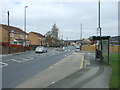
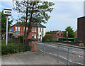
Bus stop and shelter on Cinderhill Road
Looking north east.
Image: © JThomas
Taken: 27 Mar 2017
0.01 miles
3

Sign for the Headstocks public house, Cinderhill
Image: © JThomas
Taken: 27 Mar 2017
0.03 miles
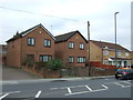
4
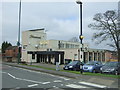
The Headstocks, Cinderhill
Almost the last reminder that this was a coal-mining area. Cinderhill Colliery closed in the 1980s.
Image: © Alan Murray-Rust
Taken: 18 Sep 2016
0.04 miles
5
Headstocks public house, Cinderhill
On Bagnall Road.
Image: © JThomas
Taken: 27 Mar 2017
0.04 miles
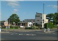
6
Headstocks public house, Cinderhill
On Bagnall Road.
Image: © JThomas
Taken: 27 Mar 2017
0.04 miles
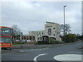
7

The Headstocks, Cinderhill
The name of this very angular pub, seen from Bagnall Road, relates to Babbington Colliery, which was a short distance west of here and closed in the 1990s.
Image: © Richard Vince
Taken: 29 Sep 2012
0.04 miles
8
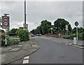
Bagnall Road: former railway bridges
The red-brick parapet to the right was once part of a bridge which carried Bagnall Road over the railway which linked Cinderhill Colliery to the Great Northern Railway Nottingham Victoria to Derby Friargate line. A second bridge, beyond the Belisha beacon, originally spanned the Midland Railway branch to the colliery. It now crosses the Phoenix Park branch of the NET tramway.
Image: © John Sutton
Taken: 24 Jun 2013
0.05 miles
9
Cinderhill Tram Stop - 4 (former colliery railway bridge)
The Highbury Vale to Phoenix Park branch of the Nottingham tram system is built on the formation of the Midland Railway Babbington (Cinderhill) Colliery Branch, which ran from a junction with the Midland's Nottingham to Mansfield and Worksop line where the Highbury Vale tram stop now is. The Midland line ran parallel to (and in the shadow of) the Great Northern Derbyshire Extension line to Derby, which ran on tall embankments and viaducts - of which no traces remain - between Cinderhill and Basford North. This view, taken from the entrance to the tram stop, shows the parapets of Great Northern Bridge No 2, which carried Bagnall Road over its own line to Babbington Colliery, which (along with the bridge) had originally been built by Thomas North, the owners of Babbington Colliery. The GNR cutting has been filled in and is now the site of the steps and zig-zag access ramp to the tram stop.
Image: © John Sutton
Taken: 19 May 2010
0.06 miles
10
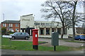
Elizabeth II postbox on Bagnall Road, Cinderhill
Postbox No. NG6 93.
Headstocks public house behind.
See Image] for postbox.
Image: © JThomas
Taken: 27 Mar 2017
0.06 miles