IMAGES TAKEN NEAR TO
Main Street, NOTTINGHAM, NG6 8QD
Introduction
This page details the photographs taken nearby to Main Street, NG6 8QD by members of the Geograph project.
The Geograph project started in 2005 with the aim of publishing, organising and preserving representative images for every square kilometre of Great Britain, Ireland and the Isle of Man.

There are currently over 7.5m images from over14,400 individuals and you can help contribute to the project by visiting https://www.geograph.org.uk
Image Map (Loading...)


Getting Data...Please wait
Leaflet Map data © OpenStreetMap
Images are licensed for reuse under creativecommons.org/licenses/by-sa/2.0
Notes
- Clicking on the map will re-center to the selected point.
- The higher the marker number, the further away the image location is from the centre of the postcode.
Image Listing (132 Images Found)
Images are licensed for reuse under creativecommons.org/licenses/by-sa/2.0
Image
Details
Distance
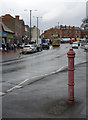
1
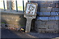
Benchmark and gas pipe marker at north end Main Street
Ordnance Survey cut mark benchmark described on the Bench Mark Database at http://www.bench-marks.org.uk/bm91697
Image: © Roger Templeman
Taken: 28 Nov 2017
0.03 miles
2
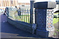
Wall with railings at Main Street / Highbury Road junction
There is an OS benchmark Image on the wall left of the gas pipe marker
Image: © Roger Templeman
Taken: 28 Nov 2017
0.03 miles
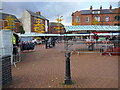
3
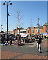
Bulwell Market
Seen from the pedestrianised Main Street in the north-east corner.
Image: © John Sutton
Taken: 1 May 2013
0.03 miles
5
Fire hydrant, Bulwell Market
One of the few survivors of the unique Nottingham design, although no longer in use.
Image: © Alan Murray-Rust
Taken: 18 Mar 2014
0.04 miles
6
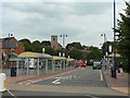
Bulwell Bus Station
A major transport hub with links to many parts of Nottingham. St Mary's Church Imagestands out on the hillside behind.
Image: © Alan Murray-Rust
Taken: 27 Aug 2009
0.04 miles
9
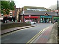
Old Stone Bridge, Bulwell
Looking towards Bulwell Market Place. The bridge dates from 1833 and was the main crossing of the River Leen in Bulwell until the end of the 19th century. Listed Grade II.
There is a bench mark http://www.geograph.org.uk/photo/5054048 on the left hand parapet at the crown of the footway.
Image: © Alan Murray-Rust
Taken: 27 Jul 2016
0.04 miles
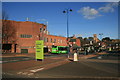
10
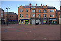
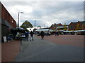
Market Place, Bulwell
Pedestrianised areas can seem lifeless, especially when there are few people around, as here in Bulwell on a Sunday. No doubt it is much busier on Tuesdays, Fridays and Saturdays when the market is held. Years ago traffic swirled round here, including, at one time, trolleybuses for whom Bulwell's market place was one of the outer termini of the Nottingham system.
Image: © Stephen McKay
Taken: 11 Nov 2012
0.04 miles