IMAGES TAKEN NEAR TO
Northall Avenue, NOTTINGHAM, NG6 8FJ
Introduction
This page details the photographs taken nearby to Northall Avenue, NG6 8FJ by members of the Geograph project.
The Geograph project started in 2005 with the aim of publishing, organising and preserving representative images for every square kilometre of Great Britain, Ireland and the Isle of Man.

There are currently over 7.5m images from over14,400 individuals and you can help contribute to the project by visiting https://www.geograph.org.uk
Image Map
Images are licensed for reuse under creativecommons.org/licenses/by-sa/2.0
Notes
- Clicking on the map will re-center to the selected point.
- The higher the marker number, the further away the image location is from the centre of the postcode.
Image Listing (49 Images Found)
Images are licensed for reuse under creativecommons.org/licenses/by-sa/2.0
Image
Details
Distance
1

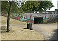
Bonington Junior Community School
The school viewed from near the subway which has drawings designed by children from the school Image
Image: © Nikki Mahadevan
Taken: 18 Feb 2007
0.10 miles
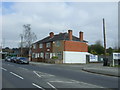
2
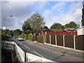
Haswell Road, Bulwell
This cul de sac off Cinderhill Road provides access to a large number of small bungalows, the roofs of two of which can be glimpsed on the right.
Image: © Richard Vince
Taken: 29 Sep 2012
0.11 miles
3
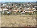
Tip top view of Bulwell
View from the top of the former Babbington Colliery spoil tip. The nearest housing is Crabtree Estate. This was one of the last large-scale housing developments undertaken by the City of Nottingham. Further off can be seen the tower of Bulwell parish church, and behind that the band of trees is Bulwell Forest, although this is not now dense woodland, being largely occupied by a golf course.
Image: © Alan Murray-Rust
Taken: 25 Oct 2009
0.12 miles
5
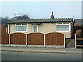
Prefab style home, Bulwell
Original style prefab still occupied 2002
Image: © John Stolarski
Taken: 16 Feb 2002
0.12 miles
6
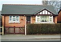
Modernised 'prefab' home, Bulwell
Prefab completely reworked with new walls, windows etc. Next door to a prefab preserved externally in its original form, also shown on this website
Image: © John Stolarski
Taken: 16 Feb 2002
0.12 miles
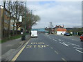
7
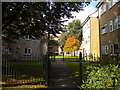
Footpath off Coventry Road, Bulwell
This footpath provides pedestrian access to some low rise blocks of flats to the west of Coventry Road, not far south of Bulwell town centre.
Image: © Richard Vince
Taken: 29 Sep 2012
0.12 miles
8
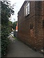
Alleyway off Coventry Road
This twichell connects the main street south of Bulwell centre to the footbridges over the River Leen and the tram and railway tracks
Image: © David Lally
Taken: 15 Sep 2017
0.14 miles
10
Subway under Seller's Wood Drive
Recreating this 'First' for the square https://www.geograph.org.uk/photo/341099
Image: © Alan Murray-Rust
Taken: 19 Jul 2022
0.15 miles