IMAGES TAKEN NEAR TO
Riseborough Walk, NOTTINGHAM, NG6 8DR
Introduction
This page details the photographs taken nearby to Riseborough Walk, NG6 8DR by members of the Geograph project.
The Geograph project started in 2005 with the aim of publishing, organising and preserving representative images for every square kilometre of Great Britain, Ireland and the Isle of Man.

There are currently over 7.5m images from over14,400 individuals and you can help contribute to the project by visiting https://www.geograph.org.uk
Image Map (Loading...)


Getting Data...Please wait
Leaflet Map data © OpenStreetMap
Images are licensed for reuse under creativecommons.org/licenses/by-sa/2.0
Notes
- Clicking on the map will re-center to the selected point.
- The higher the marker number, the further away the image location is from the centre of the postcode.
Image Listing (26 Images Found)
Images are licensed for reuse under creativecommons.org/licenses/by-sa/2.0
Image
Details
Distance
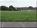
1
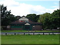
Bulwell Cricket Grounds
Recreating this 'First' for the square https://www.geograph.org.uk/photo/49357 .
The cricket facility appears to have disappeared by about 2011, with play equipment encroaching on what had been the square.
Image: © Alan Murray-Rust
Taken: 19 Jul 2022
0.06 miles
2
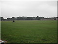
Bulwell Cricket Grounds
It also had a nice Clubhouse until the vandals did their nasty work
Image: © Tom Courtney
Taken: 5 Sep 2005
0.06 miles
3
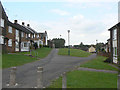
Riseborough Walk and Wingbourne Walk
Built in the style favoured in the 1960s and 70s with the front of the houses facing onto landscaped pedestrian access areas, with vehicle access at the rear.
Image: © Alan Murray-Rust
Taken: 27 Aug 2009
0.10 miles
4
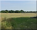
Bulwell Hall Park
The Bulwell Hall estate was taken over by Nottingham City Council and developed as recreational space, including a golf course and this cricket field.
Image: © Alan Murray-Rust
Taken: 27 Aug 2009
0.10 miles
5
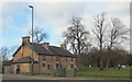
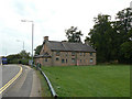
Bulwell Hall Park, Bulwell NG6, Notts.
A glimpse of the A6002 as it passes in front of "Chris Firth's Cottages", seen here occupying a corner of Bulwell Hall Park. They were formerly known as "Stone Cottages" and were built (date?) to house estate workers. The building may still be housing a municipal toy library?
Image: © David Hallam-Jones
Taken: 22 Feb 2014
0.11 miles
6
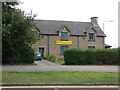
Bulwell Community Toy Library
Housed in a group of cottages built in the local stone.
Image: © Alan Murray-Rust
Taken: 27 Aug 2009
0.12 miles
7
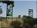
Silhouettes, Bulwell Hall Park
Fishing and insect life depicted in this pair.
Image: © Alan Murray-Rust
Taken: 19 Jul 2022
0.12 miles
8
Chris Firth Cottages
Originally estate cottages on the Bulwell Hall Estate, they now house a community toy library Image
Image: © Alan Murray-Rust
Taken: 27 Aug 2009
0.12 miles
9
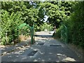
Bulwell Hall Park gateway
Road access into the park and to the golf club.
Image: © Alan Murray-Rust
Taken: 19 Jul 2022
0.13 miles