IMAGES TAKEN NEAR TO
Caldon Green, NOTTINGHAM, NG6 8DA
Introduction
This page details the photographs taken nearby to Caldon Green, NG6 8DA by members of the Geograph project.
The Geograph project started in 2005 with the aim of publishing, organising and preserving representative images for every square kilometre of Great Britain, Ireland and the Isle of Man.

There are currently over 7.5m images from over14,400 individuals and you can help contribute to the project by visiting https://www.geograph.org.uk
Image Map
Images are licensed for reuse under creativecommons.org/licenses/by-sa/2.0
Notes
- Clicking on the map will re-center to the selected point.
- The higher the marker number, the further away the image location is from the centre of the postcode.
Image Listing (38 Images Found)
Images are licensed for reuse under creativecommons.org/licenses/by-sa/2.0
Image
Details
Distance
1
Aston Drive
The Bulwell Hall Estate was part of the expansion of social housing in Nottingham in the late 1930s. The house were originally plain brick, in the style of the one in the centre, but most have now been modernised with an extra skin, with rendered finish, to improve insulation.
Image: © Alan Murray-Rust
Taken: 18 Mar 2014
0.10 miles
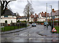
2
Bulwell - Grindon Crescent Junction with Hucknall Lane (A6002)
Image: © Alan Heardman
Taken: 21 Oct 2007
0.13 miles
3
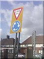
UK Give Way To The Right Mini Roundabout Sign Part 2
UK Give Way To The Right Mini Roundabout Sign Part 2 on 269 Hucknall Lane, Nottingham Nottinghamshire.
Image: © gary
Taken: 28 Jul 2015
0.13 miles
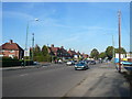
4
Moor Bridge, Bulwell
A notorious traffic bottleneck, Moor Bridge is the point at which the A611 crosses the railway line and tramway north of Bulwell and turns north to adopt Hucknall Lane (left) as its route towards Hucknall.
Image: © Richard Vince
Taken: 15 Sep 2012
0.14 miles
5
UK Pelican Crossing
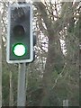
UK Pelican Crossing On Hucknall Lane, Nottingham Nottinghamshire.
Image: © gary
Taken: 2 Feb 2016
0.14 miles
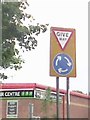
6
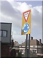
UK Give Way To The Right Mini Roundabout Sign
UK Give Way To The Right Mini Roundabout Sign on Moor Bridge, Nottingham Nottinghamshire.
Image: © gary
Taken: 3 Mar 2015
0.15 miles
7
UK Give Way To The Right Mini Roundabout Sign Part 1
UK Give Way To The Right Mini Roundabout Sign Part 1 on Moor Bridge, Nottingham Nottinghamshire.
Image: © gary
Taken: 21 Oct 2014
0.15 miles
8
The northern edge of Bulwell Hall Estate
This was one of the council estates built in the 1930s as the city expanded to the north and west. The picture shows the backs of houses on Longford Crescent. Their gardens end at the city boundary.
Image: © John Sutton
Taken: 6 Apr 2012
0.15 miles
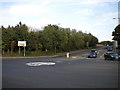
9
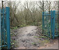
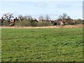
Springfield Corner Nature Reserve, Moor Bridge, Notts.
A view of the newly constructed entrance on the northern side of this small nature reserve. Commuters-in-transit and visitors can now reach the water's edge of the River Leen, at the foot of this sloping footpath, or enjoy the wild-life footpath through the reserve as a result of these improvements. Nottingham City Council reported, in its minutes of September 2012 that it had "supported the opening up of an entrance into the reserve on the north side of the site - from the Moor Bridge tram stop car park - to encourage pedestrians to use this wild-life footpath and also to be able to exit the reserve onto Hucknall Road, near to its junction with Bulwell Lane."
Image: © David Hallam-Jones
Taken: 24 Jan 2014
0.15 miles
10
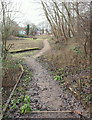
Springfield Corner Nature Reserve, Moor Bridge, Notts.
Commuters-in-transit who have left the Moor Bridge tram stop car park (behind the photographer) can now enjoy a walk through this reserve as far as Hucknall Road (ahead). Nottingham City Council reported, in its minutes of September 2012, that it had "supported the opening up of an entrance into the reserve on the north side of the site - from the Moor Bridge tram stop car park - to encourage pedestrians to use this wild-life footpath and also to be able to exit the reserve onto Hucknall Road, near to its junction with Bulwell Lane." The River Leen can be accessed at the foot of this slope via the left-hand footpath.
Image: © David Hallam-Jones
Taken: 24 Jan 2014
0.15 miles