IMAGES TAKEN NEAR TO
Grindon Crescent, NOTTINGHAM, NG6 8BW
Introduction
This page details the photographs taken nearby to Grindon Crescent, NG6 8BW by members of the Geograph project.
The Geograph project started in 2005 with the aim of publishing, organising and preserving representative images for every square kilometre of Great Britain, Ireland and the Isle of Man.

There are currently over 7.5m images from over14,400 individuals and you can help contribute to the project by visiting https://www.geograph.org.uk
Image Map (Loading...)


Getting Data...Please wait
Leaflet Map data © OpenStreetMap
Images are licensed for reuse under creativecommons.org/licenses/by-sa/2.0
Notes
- Clicking on the map will re-center to the selected point.
- The higher the marker number, the further away the image location is from the centre of the postcode.
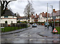
Image Listing (59 Images Found)
Images are licensed for reuse under creativecommons.org/licenses/by-sa/2.0
Image
Details
Distance
1
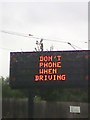
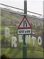
UK Warning Sign
This sign is telling drivers not to use their mobile phones while driving on the road on Hucknall Lane, Nottingham, Nottinghamshire.
Image: © gary
Taken: 28 Jul 2015
0.08 miles
2
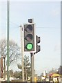
UK Pelican Crossing
UK Pelican Crossing On Hucknall Lane, Nottingham Nottinghamshire.
Image: © gary
Taken: 2 Feb 2016
0.09 miles
3
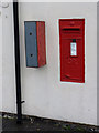
Hucknall Lane Post Office postbox ref NG6 389
Standard GR wall box. Note the remains of a relatively modern stamp vending machine alongside.
Image: © Alan Murray-Rust
Taken: 18 Mar 2014
0.09 miles
4
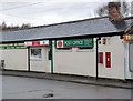
Hucknall Lane Post Office
This appears to have been built around 1950 specifically as a Post Office to serve Bulwell Hall Estate, and not as a conversion of an earlier building.
Image: © Alan Murray-Rust
Taken: 18 Mar 2014
0.09 miles
5
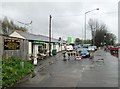
Hucknall Lane shops
A florist, a cafe and a post office, opposite Bulwell Hall Estate. No need to water the flowers on a rainy April morning.
Image: © John Sutton
Taken: 7 Apr 2014
0.09 miles
6

A Bus at Bulwell Hall Estate terminus
This photo, which was taken in May 1969, shows Leyland Atlantean 441 (DAU 441C) a 1965 Leyland Atlantean with Metro-Cammell 77-seater bodywork at the Bulwell Hall Estate terminus on the A611 Hucknall Lane. It is operated by Nottingham City Transport and is about to leave on route 44 to Colwick Road via the City Centre. This route was operated by trolleybuses until the 31st May 1965 and two trolleybus traction poles can be seen behind the bus. The building to the right of the bus has since been demolished and is now a car service centre. Semaphore railway signals can be seen on the left of the photo on the railway line that is still in use together with Nottingham's express transit system to Hucknall.
Image: © David Hillas
Taken: 3 May 1969
0.10 miles
7
UK Road Narrows To The Right Road Sign
UK Road Narrows To The Right Road Sign On Hucknall Lane, Nottingham Nottinghamshire.
Image: © gary
Taken: 28 Jul 2015
0.11 miles
8
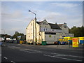
The Swinger, Bulwell Hall
On Hucknall Lane opposite Bulwell Hall estate, the Swinger stands abandoned among small industrial units related to cars. The sign on the right hand gable of the former pub depicts a tram, implying that the pub's name relates to the swinging of the trolleyboom to face the other way for the tram's return journey. However, today's Nottingham Express Transit system aside, Nottingham's tram system never extended north of Bulwell town centre (though for many years trolleybuses passed this point).
Image: © Richard Vince
Taken: 15 Sep 2012
0.11 miles
9
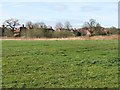
The northern edge of Bulwell Hall Estate
This was one of the council estates built in the 1930s as the city expanded to the north and west. The picture shows the backs of houses on Longford Crescent. Their gardens end at the city boundary.
Image: © John Sutton
Taken: 6 Apr 2012
0.11 miles
10
Aston Drive
The Bulwell Hall Estate was part of the expansion of social housing in Nottingham in the late 1930s. The house were originally plain brick, in the style of the one in the centre, but most have now been modernised with an extra skin, with rendered finish, to improve insulation.
Image: © Alan Murray-Rust
Taken: 18 Mar 2014
0.11 miles