IMAGES TAKEN NEAR TO
Sketchley Court, NOTTINGHAM, NG6 7DL
Introduction
This page details the photographs taken nearby to Sketchley Court, NG6 7DL by members of the Geograph project.
The Geograph project started in 2005 with the aim of publishing, organising and preserving representative images for every square kilometre of Great Britain, Ireland and the Isle of Man.

There are currently over 7.5m images from over14,400 individuals and you can help contribute to the project by visiting https://www.geograph.org.uk
Image Map (Loading...)


Getting Data...Please wait
Leaflet Map data © OpenStreetMap
Images are licensed for reuse under creativecommons.org/licenses/by-sa/2.0
Notes
- Clicking on the map will re-center to the selected point.
- The higher the marker number, the further away the image location is from the centre of the postcode.
Image Listing (6 Images Found)
Images are licensed for reuse under creativecommons.org/licenses/by-sa/2.0
Image
Details
Distance
2
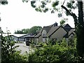
The Limekiln
Pub serving the Snape Wood area.
Image: © Alan Murray-Rust
Taken: 19 Jul 2022
0.15 miles
3
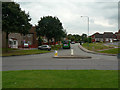
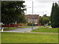
Snape Wood Road
Part of the large areas of council residential development to the west of Bulwell in the 1960s to 1980s.
Image: © Alan Murray-Rust
Taken: 27 Aug 2009
0.20 miles
4
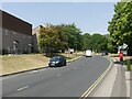
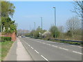
Seller's Wood Drive
The final section into Snape Wood estate.
Image: © Alan Murray-Rust
Taken: 19 Jul 2022
0.20 miles