IMAGES TAKEN NEAR TO
Bramble Close, NOTTINGHAM, NG6 0QG
Introduction
This page details the photographs taken nearby to Bramble Close, NG6 0QG by members of the Geograph project.
The Geograph project started in 2005 with the aim of publishing, organising and preserving representative images for every square kilometre of Great Britain, Ireland and the Isle of Man.

There are currently over 7.5m images from over14,400 individuals and you can help contribute to the project by visiting https://www.geograph.org.uk
Image Map
Images are licensed for reuse under creativecommons.org/licenses/by-sa/2.0
Notes
- Clicking on the map will re-center to the selected point.
- The higher the marker number, the further away the image location is from the centre of the postcode.
Image Listing (146 Images Found)
Images are licensed for reuse under creativecommons.org/licenses/by-sa/2.0
Image
Details
Distance
1
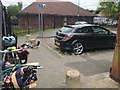
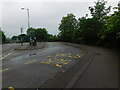
Good parking mate!
A car blocks the drop-kerb on an nasty bit of NCN route 6.
Image: © David Lally
Taken: 17 Jun 2018
0.04 miles
2
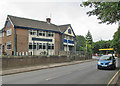
Basford: The Horse and Jockey, David Lane
Currently closed and looking drab on an overcast summer morning.
Image: © John Sutton
Taken: 7 Jul 2015
0.05 miles
3
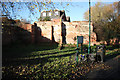
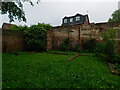
Mill Street Mill ruins
There was a watermill here in 1086, though the ruins by NCN route 6 are those of a mill built in 1833, destroyed by fire in 1938
Image: © Richard Croft
Taken: 25 Nov 2011
0.07 miles
4
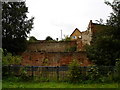
Remains of Watermill on Mill Street
The old brick walls in the photo are all that remain of the old mill on the river Leen at Mill Street, which was destroyed by fire in 1938. The mill race [http://www.geograph.org.uk/photo/949720] is located between the metal railings and the first brick wall, a few feet below ground level.
Image: © Oxymoron
Taken: 4 Sep 2008
0.07 miles
6
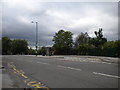
Percy Street turning circle, Old Basford
The fairly large bus turning circle on Percy Street is no longer in use, hence the position of the bus stop and shelter. Until March 2007, it was the terminus of Nottingham City Transport route 69 from Nottingham city centre via Sherwood Rise, but since then all buses serving the area have continued beyond this point.
Image: © Richard Vince
Taken: 9 Jun 2012
0.07 miles
7
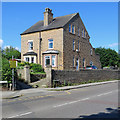
Old Basford: stone villas on Stockhill Lane
Bulwell stone is used all over Nottingham for garden walls, but rather less often for Victorian churches, chapels and houses like this substantial pair. For another view, see Image
Image: © John Sutton
Taken: 2 Jul 2019
0.08 miles
8

Bulwell stone in Basford
Bulwell stone is used all over Nottingham for garden walls, but rather less often for Victorian churches, chapels and houses like this substantial pair on Stockhill Lane, photographed against the light on a sunny July morning. For a view of the front elevation taken a short while later, see Image
Image: © John Sutton
Taken: 2 Jul 2019
0.08 miles
10
Old Basford: Firecrest Way
One of several streets off Mill Street which are named after birds.
Image: © John Sutton
Taken: 2 Jul 2019
0.08 miles